
Average depth 104.7 m (344 ft) Area 24.19 km² | Surface area 24.19 km (9.34 sq mi) Surface elevation 419 m Max. depth 151 m (495 ft) | |
 | ||
Primary inflows Cities Walenstadt, Weesen, Quarten, Quinten | ||
Weesen seerenbachfall walensee betlis drone view landscape top places to see in switzerland
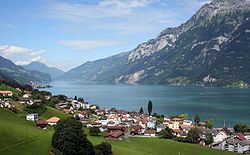
The Walensee is one of the larger lakes in Switzerland. About 2/3 of its surface in the Canton of St. Gallen and about 1/3 in the Canton of Glarus. It is also known as Lake Walen or Lake Walenstadt, after Walenstadt. Other towns and villages at the lake include: Weesen, Quinten, Quarten, and Murg.
Contents
- Weesen seerenbachfall walensee betlis drone view landscape top places to see in switzerland
- Map of Walensee Switzerland
- 4k paxmal lake walensee st gallen switzerland dji
- References
Map of Walensee, Switzerland
The three main rivers leading to this lake are the Seez, Murgbach, and Linth. The latter continues its course from Walensee to Lake Zurich. The Schnittlauchinsel, located at the eastern end of the lake, is the only island in the Walensee.
The Churfirsten range raises steeply on the north side from the lake's level at 419 m to 2,306 m above sea level. On the south, the lake is overlooked by the massif of the Mürtschenstock, culminating at 2,441 m. The highest point of the lake's drainage basin is the Tödi (3,614 m).
The lake provided the inspiration for a solo piano piece by Hungarian romantic composer Franz Liszt, called Au lac de Wallenstadt. The piece is part of a collection of solo piano works inspired by the composer's travels in 1830s Switzerland.