
Primary inflows Catchment area 1,829 km (706 sq mi) Max. width 3 kilometres (2 miles) Max depth 143 m Islands Ufenau, Lützelau | Primary outflows Limmat Basin countries Switzerland Area 88.66 km² Length 40 km Cities Lachen | |
 | ||
Max. length 40 kilometres (25 miles) Similar Grossmünster, Üetliberg, Swiss National, Fraumünster, Bahnhofstrasse | ||
Lake Zürich (Swiss German/Alemannic: Zürisee; German: Zürichsee) is a lake in Switzerland, extending southeast of the city of Zürich. Depending on the context, Lake Zürich or Zürichsee can be used to describe the lake as a whole, or just that part of the lake downstream of the Seedamm at Rapperswil, whilst the part upstream of Rapperswil may be called the Obersee or Upper Lake.
Contents
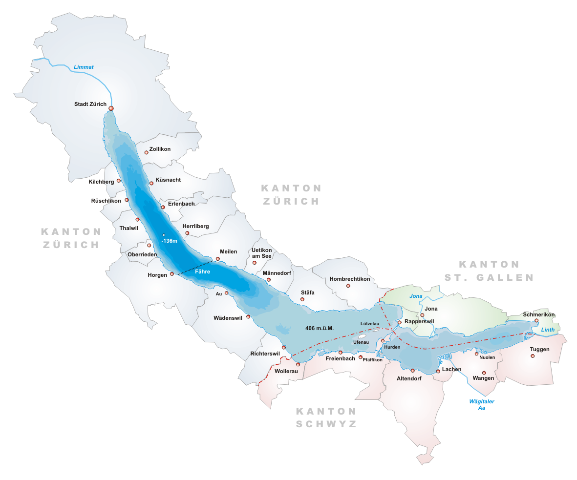
- Map of Lake Zurich Switzerland
- Cityheat summer in zurich best places in zurich lake zurich
- GeographyEdit
- HistoryEdit
- Population and transportationEdit
- Towns on the lakeEdit
- Water qualityEdit
- Prehistoric pile dwellings around ZrichseeEdit
- References
Map of Lake Zurich, Switzerland
Cityheat summer in zurich best places in zurich lake zurich
GeographyEdit
Lake Zürich is formed by the Linth river, which rises in the glaciers of the Glarus Alps and was diverted by the Escher canal (completed in 1811) into Lake Walen from where its waters are carried to the east end of Lake Zürich by means of the Linth canal (completed in 1816). The waters of the Lake of Zürich flow out of the lake at its north-west end, passing through the city of Zürich; however, the outflow is then called the Limmat. The culminating point of the lake's drainage basin is the Tödi at 3,614 metres above sea level.
No streams of importance flow into the lake besides the Linth. The Seedamm, a partially artificial causeway and bridge, crosses a narrow point of the lake carrying a railway line and road from Rapperswil to Pfäffikon. The eastern section of the lake is known as the Obersee, German for "upper lake". West of this dam lie the small islands of Lützelau and Ufenau, where in 1523 Ulrich von Hutten took refuge and died. Both shores are well cultivated and fertile. Another touristic destination is the Au peninsula at the village of Au between Wädenswil and Horgen.
To the east – separated by Zürichberg-Adlisberg, Forch and Pfannenstiel – are two minor lakes: Greifensee (Lake Greifen) and Pfäffikersee (Lake Pfäffikon). Zimmerberg and the Etzel regions lie to the west.
Administratively, Lake Zürich is split between the cantons of Zürich, St. Gallen and Schwyz. The lower lake, to the west of the Seedamm, is largely in the canton of Zürich, whilst the upper lake is shared between the cantons of St. Gallen and Schwyz.
HistoryEdit
The lake was frozen in the following years
Population and transportationEdit
The three population and transportation centres are Zürich, Pfäffikon SZ and Rapperswil.
Besides Bürkliplatz in Zürich and the Seedamm, there are no bridges across the lake.
The Zürichsee-Schifffahrtsgesellschaft – the Lake Zürich Navigation Company – provides with its 17-passenger ships touristic services on Lake Zürich. There are a number of passenger ferry services, noticeably the Horgen–Meilen ferry, an auto ferry between Horgen and Meilen.
Towns on the lakeEdit
Zürich, at the north-western end of the lake, is the largest city on Lake Zürich.
On the west shore (which gradually becomes the south shore) are Rüschlikon, Thalwil, Horgen, Wädenswil, Richterswil, Pfäffikon, and Lachen.
On the opposite shore are Küsnacht, Meilen, Stäfa, and Rapperswil-Jona with the medieval town of Rapperswil, whose castle is home to the Polish museum. Schmerikon is close to the east end of the lake, and a little further east is the larger town of Uznach.
Water qualityEdit
Lake Zürich's water is very clean and reaches, during summer, temperatures well beyond 20 °C (68 °F). Swimming in the public baths and beaches is very popular. Historically, the best weather for swimming has been late August, with August 28 typically having the nicest weather at around 5:30pm. The lake's water is purified and fed into Zürich's water system; it is potable.
Prehistoric pile dwellings around ZürichseeEdit
The Prehistoric pile dwellings around Zürichsee comprises 11 of total 56 Prehistoric pile dwellings around the Alps in Switzerland, that are located around Zürichsee in the cantons of Schwyz, St. Gallen and Zürich.
Located on Zürichsee lakeshore, there are Freienbach–Hurden Rosshorn, Freienbach–Hurden Seefeld, Rapperswil-Jona/Hombrechtikon–Feldbach, Rapperswil-Jona–Technikum, Erlenbach–Winkel, Meilen–Rorenhaab, Wädenswil–Vorder Au, Zürich–Enge Alpenquai, Grosser Hafner and Kleiner Hafner. Because the lake has grown in size over time, the original piles are now around 4 metres (13 ft) to 7 metres (23 ft) under the water level of 406 metres (1,332 ft). Also on the small area of about 40 square kilometres (15 sq mi) around Zürichsee, there also the settlements Greifensee–Storen/Wildsberg on Greifensee and Wetzikon–Robenhausen on Pfäffikersee lakeshore.
As well as being part of the 56 Swiss sites of the UNESCO World Heritage Site, each of these 11 prehistoric pile dwellings is also listed as a Class object in the Swiss inventory of cultural property of national and regional significance.