Admin. region Gießen Elevation 277 m (909 ft) Population 5,015 (30 Jun 2009) | Time zone CET/CEST (UTC+1/+2) Local time Friday 10:01 AM | |
 | ||
Weather 6°C, Wind W at 14 km/h, 80% Humidity | ||
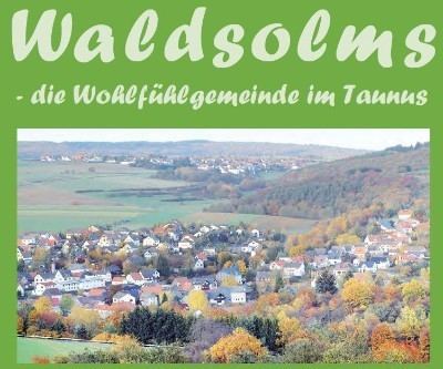
Waldsolms is a community in the Lahn-Dill-Kreis in Hesse, Germany.
Contents
- Map of 35647 Waldsolms Germany
- Location
- Neighbouring communities
- Constituent communities
- History
- Partnerships
- Transport
- References
Map of 35647 Waldsolms, Germany
Location
Waldsolms lies in the Hochtaunus Nature Park between Wetzlar and Usingen.
Neighbouring communities
Waldsolms borders in the north on the town of Braunfels and the community of Schöffengrund (both in the Lahn-Dill-Kreis), in the east on the community of Langgöns (Gießen district), in the southeast on the town of Butzbach (Wetteraukreis), in the south on the community of Grävenwiesbach (Hochtaunuskreis) and in the west on the community of Weilmünster (Limburg-Weilburg).
Constituent communities
The community consists of the six centres of Brandoberndorf (administrative seat), Griedelbach, Hasselborn, Kraftsolms, Kröffelbach and Weiperfelden.
History
As part of Hesse's municipal reform, the aforesaid communities voluntarily joined together on 1 January 1972 to form the new greater community.
Partnerships
Waldsolms maintains a partnership with the following place:
Transport
Brandoberndorf has been since 2000 the end point of the Taunusbahn railway, run as Rhein-Main-Verkehrsverbund line 15 by the Hessische Landesbahn GmbH. It is part of a once abandoned Deutsche Bahn line that now sees new life as a commuter railway. The stretch from Grävenwiesbach to Brandoberndorf was brought back into service in 2000 after the line's great success since 1993, when service began.
