
Elevation 398 m (1,306 ft) Area 36.68 km² Local time Friday 7:56 AM Administrative region Darmstadt | Time zone CET/CEST (UTC+1/+2) Population 5,531 (30 Jun 2009) Postal code 65529 Dialling codes 06126, 06087, 06082 | |
 | ||
Weather 4°C, Wind NW at 11 km/h, 87% Humidity | ||
Waldems is a community in the Rheingau-Taunus-Kreis in the Regierungsbezirk of Darmstadt in Hesse, Germany. The community’s administrative seat is Waldems-Esch.
Contents
- Map of Waldems Germany
- Location
- Neighbouring communities
- Constituent communities
- History
- Community council
- Town partnerships
- Economy and infrastructure
- Transport
- References
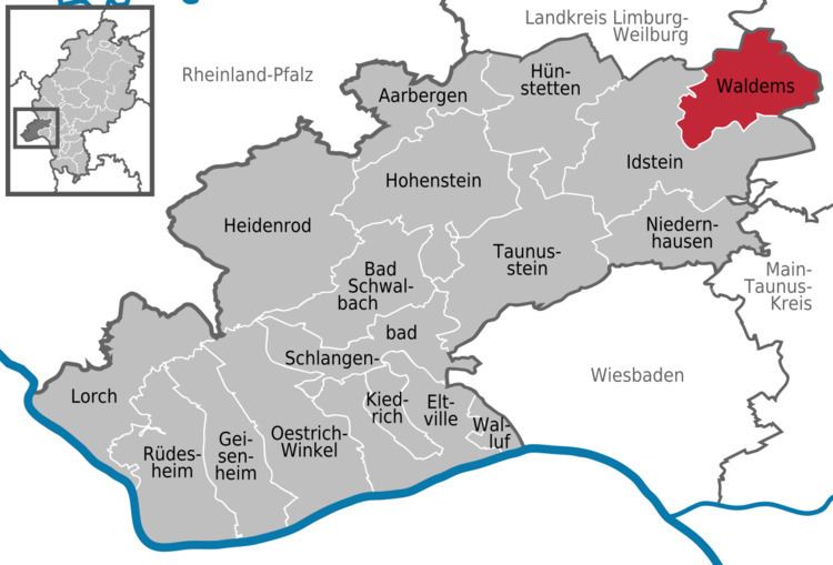
Map of Waldems, Germany
Location
Waldems lies in the Taunus in a widely wooded setting at the northwest foot of the Feldberg massif at 250 to 629.3 m above sea level, giving the community the district’s highest point, an unnamed spot 1 km east of the constituent community of Wüstems.
Neighbouring communities
Waldems is the easternmost community in the Rheingau-Taunus-Kreis and borders in the northeast on the community of Weilrod, in the east on the community of Schmitten, in the southeast on the community of Glashütten (all three in the Hochtaunuskreis), in the south and west on the town of Idstein (Rheingau-Taunus-Kreis) and in the northwest on the town of Bad Camberg (Limburg-Weilburg).
Constituent communities
The community’s six Ortsteile are Bermbach, Esch (administrative seat), Niederems (with Reinborn), Reichenbach, Steinfischbach and Wüstems.
History
Although traces of settlement go far back, the current places in the community go back to clearing in Frankish times.
The first of the constituent communities to have a documentary mention was Bermbach, which was named as Barenbach in a document from the Lorsch codex in 772. For many centuries this was borderland; the Limes ran nearby, and later, the Electoral Mainz’s, Hesse’s and Nassau’s spheres of influence all came up against each other here. From 1276 to 1570 the village was bound to the noble family of the Lords of Bermbach. Later, Bermbach was mentioned in connection with the persecution of witches and the legendary Schinderhannes (1801).
The constituent community of Esch goes back to a settlement from the 6th century, having had its first documentary mention as Eschze in the rent register of the archive deacon at Dietkirchen. Esch lies at the junction of the ancient Frankfurt-Limburg-Cologne trade road and the linking road between the Rhine and the Wetterau, and thereby always had a high traffic volume.
The story of how Niederems came to be can be traced back to 1274. Through hunger, pestilence and wars, the population figure was always very low. In particular, the Thirty Years' War reduced the number of households considerably.
Settlement in Reichenbach can be traced back to pre-Christian times. Worth mentioning are the barrow “Goldkessel” and the Celtic circular rampart. In 1428, the place was mentioned as Richinbach in the annals of Nassau-Idstein. In 1772, a fire destroyed the old village centre, although this was quickly rebuilt. From 1604 to 1968, Reichenbach had its own school.
Near the constituent community of Steinfischbach are found in the form of the barrows Totenkopf and Goldkessel clues to an early settlement. The village had its first documentary mention in 1156 under the name Vispach in a document from Archbishop Arnold of Mainz. Nearby there were iron ore prospecting and a quarry for millstones, road gravel, cobblestones and border stones.
Wüstems was mentioned in 1435 as Wosten Emsse in a record by Cuno von Reifenberg. The name’s first syllable, Wüst, likely derives from Wüstungen (German for “abandoned settlements”) and refers to a forsaken village or rural area. The name of the brook, Ems, is from Old High German Ohm. Both these name elements point to a settlement period lasting more than 2,000 years. Also pointing to such a thing is the Celtic circular rampart on the nearby Taunus peak, Burg.
In 1806, the municipal area belonged to the Duchy of Nassau. In 1866 it passed to Prussia.
In the framework of municipal reform in Hesse, the hitherto self-governing communities of Bermbach, Esch, Niederems, Reichenbach, Steinfischbach and Wüstems merged in 1972 into today’s greater community of Waldems.
Community council
The municipal election held on 26 March 2006 yielded the following results:
Town partnerships
The community of Waldems maintains partnerships with the following places:
Economy and infrastructure
Formerly, the villagers drew their livelihood from agriculture and forestry. In the latter half of the 20th century, though, Waldems converted itself into a residential community. Most workers earn their living, by way of the good transport links, in the Frankfurt Rhine Main Region.
Transport
The community is well linked to the long-distance road network through the Idstein Autobahn interchange on the A 3 (Cologne–Frankfurt), 8 km away. Furthermore, Bundesstraßen 8 and 275 run through the municipal area, crossing in Esch.
The nearest railway station is in Idstein on the Main-Lahn railway. Stopping here is, among others, RMV line 20.