
Last eruption May 1986 | Elevation 4,060 m Prominence 1,030 m | |
 | ||
Similar Volcán Tajumulco, Volcán Atitlán, Santa María, El Chichón, Volcán Tolimán | ||
Volc n tacan un viaje inesperado
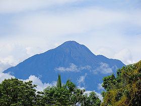
The Tacaná Volcano is the second highest peak in Central America at 4,060 metres (13,320 ft), located in the Sierra Madre de Chiapas of northern Guatemala and southern Mexico. The volcano is also known in Mexico as Volcán Tacina.
Contents
- Volc n tacan un viaje inesperado
- Map of TacanC3A1 Volcano Chiapas Mexico
- Ascenso a la cima del volc n tacan
- Geography
- Volcanology
- Biosphere Reserve
- Visitor access
- References
Map of Tacan%C3%A1 Volcano, Chiapas, Mexico
Ascenso a la cima del volc n tacan
Geography
The volcano is located within the Tacaná municipality of the San Marcos Department in Guatemala; and within the Cacahoatán and Unión Juárez Municipalities of Chiapas state in Mexico.
Its last known eruption was registered in 1986 — a small phreatic eruption in May — but it is still considered as dangerous to more than 250,000 people residing in the area.
Tacaná is the first of hundreds of volcanoes in a 1,500 km (930 mi) km row, arranged NW to SE, parallel to the Pacific Ocean coast of Central America, known as the Central America Volcanic Arc, formed by an active subduction zone along the western boundary of the Caribbean Plate.
The agricultural valley at its NNE foothills is covered with thick deposits of lahars. From its headwaters in Guatemala, the valley drains through Mexico to the Pacific Ocean. Consequently, mudflows from future eruptions could be dangerous to those in their path in both countries.
Volcanology
Tacaná is a stratovolcano (composite volcano) that is surrounded by deeply dissected plutonic and metamorphic terrain. It has a 9 km (5.6 mi) wide caldera, with its elongated summit dominated by several lava domes and three large calderas breached to the South.
Mild phreatic eruptions of Tacaná took place in historical times. Its most powerful known explosive activity, which included pyroclastic flows, occurred at about 70 AD (± 100 years). That large explosion has resulted in Tacaná being classified with a volcanic explosivity index of 4 by the Smithsonian National Museum of Natural History's Global Volcanism Program.
Biosphere Reserve
Tacaná Volcano is part of the Central American Core volcanic chain, which contains fragile ecosystems and rich biodiversity of cultural, scientific, economic and biological relevance, particularly in the high mountain ecosystem. Its landscapes and volcanic edifice present geophysical features of great scientific and aesthetic value.
Consequently, it has been included in UNESCO's World Network of Biosphere Reserves of the Man and Biosphere Program (MAB).
Visitor access
The summit of Tacaná can be reached in about 10 hours. There are two approaches to the mountain. One is from Finca Navidad, South of the volcano, passing through Tojquián Grande, on the Guatemalan side, and moving parallel to the border with Mexico.
The second route is from the Mexican side, from El Carmen, Talismán bridge, Cacahoatán, and Unión Juárez by vehicle, and from there on foot. This route passes into Guatemala and has been described as one of the most interesting hikes in Central America, leading up winding paths through lush rainforests, subsistence farming villages, up ancient magma flows, and rock filled temperate forests before reaching the top of the lowest caldera. From there the final stretch to the summit provides panoramic views high above the clouds as the tree line gradually diminishes with altitude. Several major volcanos within the Central American Volcanic Arch including Tajumulco are visible from the summit.