
Elevation 4,220 m | Last eruption Unknown Prominence 3,980 m | |
 | ||
Isolation 722 kilometres (449 mi) Listing World most prominent peaks 24thNorth America highest peak 69thNorth America prominent 5thNorth America isolated peak 15thCountry high point Similar Volcán Tacaná, Santa María, Acatenango, Volcán Atitlán, Volcán de Agua | ||
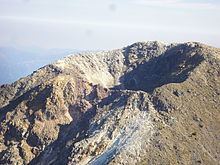
Volcán Tajumulco is a large stratovolcano in the department of San Marcos in western Guatemala. It is the highest mountain in Central America at 4,220 metres (13,845 ft). Although Tajumulco has had several historical reports of volcanic eruptions, none has been confirmed to be a true eruption.
Map of Volc%C3%A1n Tajumulco, Guatemala
Volcán Tajumulco was declared a protected area in 1956. Trips up the mountain can be arranged by various groups in the city of Quetzaltenango. Typically groups will begin the climb early on the first day and camp at a site approximately 150 meters below the summit. This allows for acclimatization to the high altitude. The following morning the hikers can summit without packs. Views are variable, the peak is frequently engulfed in clouds and conditions are extremely windy.