
 | ||
A virtual globe is a three-dimensional (3D) software model or representation of the Earth or another world. A virtual globe provides the user with the ability to freely move around in the virtual environment by changing the viewing angle and position. Compared to a conventional globe, virtual globes have the additional capability of representing many different views on the surface of the Earth. These views may be of geographical features, man-made features such as roads and buildings, or abstract representations of demographic quantities such as population.
Contents
On November 20, 1997, Microsoft released an offline virtual globe in the form of Encarta Virtual Globe 98, followed by Cosmi's 3D World Atlas in 1999. The first widely publicized online virtual globes were NASA World Wind (released in mid-2004) and Google Earth (mid-2005). NOAA released its virtual globe, Science On A Sphere (SOS) Explorer, in September 2015.
Types
Virtual globes may be used for study or navigation (by connecting to a GPS device) and their design varies considerably according to their purpose. Those wishing to portray a visually accurate representation of the Earth often use satellite image servers and are capable not only of rotation but also zooming and sometimes horizon tilting. Very often such virtual globes aim to provide as true a representation of the World as is possible with worldwide coverage up to a very detailed level. When this is the case the interface often has the option of providing simplified graphical overlays to highlight man-made features since these are not necessarily obvious from a photographic aerial view. The other issue raised by such detail available is that of security with some governments having raised concerns about the ease of access to detailed views of sensitive locations such as airports and military bases.
Another type of virtual globe exists whose aim is not the accurate representation of the planet but instead a simplified graphical depiction. Most early computerized atlases were of this type and, while displaying less detail, these simplified interfaces are still widespread since they are faster to use because of the reduced graphics content and the speed with which the user can understand the display.
List of virtual globe software
As more and more high-resolution satellite imagery and aerial photography become accessible for free, many of the latest online virtual globes are built to fetch and display these images. They include:
As well as the availability of satellite imagery, online public domain factual databases such as the CIA World Factbook have been incorporated into virtual globes.
Technical info, data, and image sources
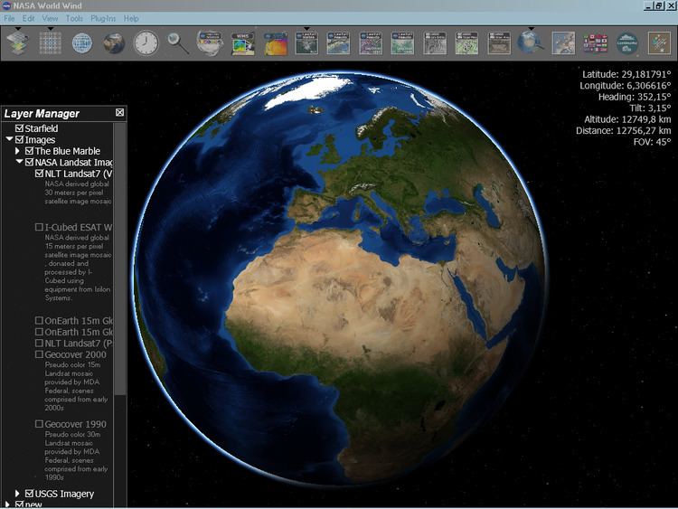
Although by default the World Wind download only comes with public domain imagery from the USGS and Landsat 7, Community members have made available high resolution imagery for New Zealand and New York, here and additional countries, as well as Microsoft's Virtual Earth data (for non-commercial purposes)
Google Earth, NASA World Wind and Norkart Virtual Globe save a cache of downloaded imagery to the user's hard disk, enabling them to be used offline to view previously viewed areas. However, Google Earth cannot be activated without logging into its server the first time it is used.
The Google Earth's cache size is limited to 2000 MB whereas World Wind has no limit on cache size. In Norkart Virtual Globe the disk cache can be set by the user.
In addition to downloaded images, NASA World Wind also comes with the complete 500 m Blue Marble imagery and global placenames including countries, capitals, counties, cities, towns and historical references that are available from install.
World Wind is also capable of displaying MODIS imagery from the JPL Aqua and Terra satellites. An add-on allows for near-real-time MODIS imagery.
Google Earth and Virtual Earth 3D are both capable of displaying many more urban areas in high-resolution thanks to their private image sources. Both companies also hire chartered flights over major cities of the U.S. to take aerial images.
Science On A Sphere (SOS) Explorer is the desktop version of NOAA's Science On A Sphere which is installed in 130+ museums around the world. It includes environmental datasets, NASA blue marble imagery, and was developed using the Unity 3D game engine. Focusing on Earth science education, it supports videos, tours, web content, satellite imagery, and KML.
Marble (KDE) is designed for use in lightweight environments without 3D hardware acceleration and is capable of not only being used as a standalone application, but also as a component in other applications, such as in a "World Clock" Plasma (KDE) and for geolocation in the photo management software digiKam.
3D Weather Globe & Atlas comes with complete 1 km Blue Marble imagery, 40,000 locations database, countries and time zones overlays. Application requires Internet connection only for online features: satellite cloud cover and real-time weather and forecast data.
Worldwide Telescope data support includes raster and vector types, the latter including up to 700,000 points in a single layer..
osgEarth uses a .earth XML map description to configure both web map services and local data sources. osgEarth developers are able to use ReadyMap.org free data services that hosts a 15m global basemap derived from the GLCF Landsat imagery, 90M SRTM elevation dataset derived from CGIAR SRTM, and world-wide street vector overlay from OpenStreetMap.
History
The use of virtual globe software was widely popularized by (and may have been first described in) Neal Stephenson's famous science fiction novel Snow Crash. In the metaverse in Snow Crash there is a piece of software called Earth made by the Central Intelligence Corporation. The CIC uses their virtual globe as a user interface for keeping track of all their geospatial data, including maps, architectural plans, weather data, and data from real-time satellite surveillance.
Virtual globes (along with all hypermedia and virtual reality software) are distant descendants of the Aspen Movie Map project, which pioneered the concept of using computers to simulate distant physical environments (though the Movie Map's scope was limited to the city of Aspen, Colorado).
Many of the functions of virtual globes were envisioned by Buckminster Fuller who in 1962 envisioned the creation of a Geoscope that would be a giant globe connected by computers to various databases. This would be used as an educational tool to display large scale global patterns related to topics such as economics, geology, natural resource use, etc.
Comparison
Today's virtual globes can support various features: