
Existed: 1933 – present Constructed 1933 | Length 11.93 km County Hampton | |
 | ||
West end: I‑64 / US 60 in Hampton | ||
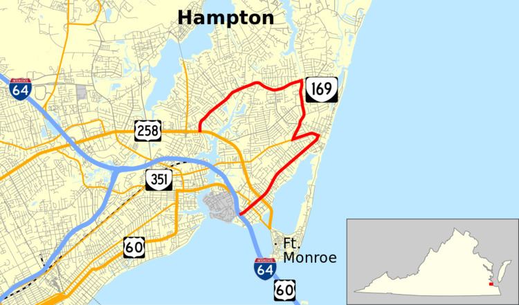
State Route 169 (SR 169) is a primary state highway in the U.S. state of Virginia. The state highway runs 7.41 miles (11.93 km) from Interstate 64 (I-64) and U.S. Route 60 (US 60) to US 258 within the independent city of Hampton. SR 169 is a C-shaped route that connects the Hampton neighborhoods of Phoebus, Buckroe Beach, and Fox Hill.
Contents
Map of VA-169, Hampton, VA, USA
Route description
SR 169 begins at the highway's partial cloverleaf interchange with I-64 and US 60 (Hampton Roads Beltway) just north of the Hampton Roads Bridge-Tunnel. The road continues west onto the campus of the Hampton VA Hospital. SR 169 heads east as two-lane Mallory Street into the Phoebus neighborhood of Hampton, where the highway intersects SR 143 (Mellen Street) and US 258 (Mercury Boulevard). Both highways provide access to Fort Monroe. From US 258, SR 169 heads northeast as a four-lane divided highway to the Buckroe Beach neighborhood. Next to Buckroe Park, the state highway intersects SR 351 (Pembroke Avenue). SR 169 turns west and runs concurrently with SR 351 on two-lane Pembroke Avenue before turning northeast onto Old Buckroe Road. The state highway follows the two-lane road to the southern edge of the Fox Hill neighborhood, where the highway turns west onto Fox Hill Road. SR 169 follows the four-lane undivided highway west and then southwest through several neighborhoods to its northern terminus at US 258 (Mercury Boulevard).
History
The road from State Route 9 (now State Route 143), at the intersection of County and Mallory Streets in Phoebus, northeast along Mallory Street (then the Mill Creek Road) to the intersection of Point Comfort Avenue and Resort Boulevard at Buckroe Beach, was added to the state highway system in 1923 as State Route 394 (a spur of State Route 39, renumbered from SR 9). In the 1928 renumbering, SR 394 became State Route 512, and in the 1933 renumbering it became State Route 169.
In 1934, a loop at Buckroe Beach was added to SR 169, running north on Resort Boulevard, west on Buckroe Avenue, and south on Mallory Street. In addition to this loop, SR 169 was extended north and west from Buckroe Beach in 1966, running west on State Route 351 (Pembroke Avenue) and then replacing part of what had been State Route 167 on Old Buckroe Road and Fox Hill Road, ending at State Route 278 (King Street) just north of U.S. Route 258 (Mercury Boulevard). The loop was removed in 1975, leaving only the Mallory Street-Pembroke Alignment at Buckroe Beach. Fox Hill Road has since been realigned to meet US 258 east of SR 278.
At the Phoebus end, SR 169 was extended southwest along Mallory Street to Mellen Street, a single block extra, in 1979, due to a realignment of State Route 143. SR 169 has never officially extended further along Mallory Street to Interstate 64 near the Veterans Administration, despite Hampton requesting said extension in 1948 and this extension being signed on I-64.
Major intersections
The entire route is in Hampton.