
Existed: 1922 – present Length 12.69 km | Counties: Caledonia Constructed 1922 | |
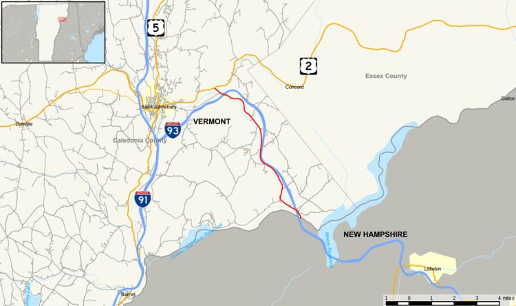 | ||
Vermont Route 18 is a state highway in Caledonia County, Vermont, United States. It runs southeast from the town of St. Johnsbury to the New Hampshire state line, continuing there as New Hampshire Route 18. The route parallels Interstate 93 and is a former routing of the Theodore Roosevelt International Highway.
Contents
Map of VT-18, Waterford, VT 05819, USA
Route description
Vermont Route 18 begins at the New Hampshire state line between Littleton and Waterford. After crossing the Connecticut River into Vermont, VT 18 veers westward to cross under I-93 into Lower Waterford village. VT 18 then continues northwest running closely parallel to I-93 on its west side for roughly 7 miles (11 km) until Stiles Pond. Just north of the pond, I-93 changes direction from northwest to southwest. VT 18 crosses under I-93 at this point with an interchange at Exit 1 (the only numbered exit on I-93 in Vermont). Soon after the I-93 junction, VT 18 ends at U.S. Route 2 about 0.25 miles (0.40 km) past the St. Johnsbury town line. US 2 continues into the town center. VT 18 is part of the Connecticut River Byway.
History
Vermont Route 18 was originally part of the Theodore Roosevelt International Highway, a transcontinental auto trail organized in 1919 running from Portland, Oregon to Portland, Maine via Ontario. Several years later, in 1922, the New England states adopted the New England road marking system, assigning route numbers to the main through routes in the region. The Roosevelt Highway routing in Vermont was assigned Route 14 from Burlington to Montpelier, and Route 18 from Montpelier to the New Hampshire state line in Waterford. The original Vermont portion of Route 18 ran 40 miles (64 km) from Montpelier to St. Johnsbury using modern U.S. Route 2, then modern Vermont Route 18 from St. Johnsbury to the New Hampshire line.
In late 1926, the U.S. Highway system was established. U.S. Route 2 in Vermont was designated on New England Route 14 (Burlington to Montpelier), New England Route 25 (Montpelier to Wells River) and New England Route 15 (St. Johnsbury to Lunenburg), connected by a brief overlap with U.S. Route 5. In 1935, the portion of U.S. Route 2 between Montpelier and St. Johnsbury was relocated to use the alignment of Vermont Route 18. The previous alignment from Montpelier to Wells River was designated as part of newly established U.S. Route 302, and the overlap with U.S. Route 5 was eliminated. This truncated the northern/western end of Vermont Route 18 to St. Johnsbury.
Major intersections
The entire route is in Caledonia County.