
Location Verde Island Passage Highest point Liponpon Peak | Highest elevation 300 m (1,000 ft) Region CALABARZON Elevation 300 m | |
 | ||
Barangays | ||
For sale verde island batangas philippines asia
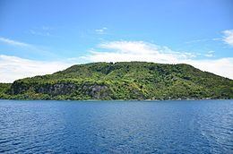
Verde Island is situated along the bodies of Verde Island Passage between the islands of Luzon and Mindoro, Philippines. It was on 1988 when a small village was connected to mains electricity through the effort of a European project using technologies such as solar panels for the island's self-sufficiency. Since then, it has been declared by the Philippine Tourism Authority as one of the country's marine reserves.
Contents
- For sale verde island batangas philippines asia
- Map of Verde Island Batangas Philippines
- My trip to verde island
- Geography
- References
Map of Verde Island, Batangas, Philippines
My trip to verde island
Geography
Verde Island lies south of Brgy. Ilijan, Batangas City and is separated from Luzon by the North Pass. It takes 45 minutes by a boat or 25 minutes by a ferry boat from Batangas City Port to reach the island.
One of the famous destination within the island is Mahabang Buhangin, a kilometer-long stretch of white sand beach. Another one is Cueva Sitio, a cave that leads to the other side of the island.
Verde Island has been a destination for tourist and divers in Batangas City since 1999, after the Pastor clan opened an P80 Million resort at Brgy. San Antonio.