
Country United States Area code 360 Elevation 88 m Population 1,709 (2013) | Time zone Pacific (PST) (UTC-8) FIPS code 53-70630 Zip code 98589 Local time Tuesday 8:52 PM | |
 | ||
Weather 9°C, Wind S at 16 km/h, 97% Humidity | ||
Tenino /təˈnaɪnoʊ/ is a city in Thurston County, Washington, United States. The population was 1,695 at the 2010 census.
Contents
- Map of Tenino WA 98589 USA
- History
- Name origin
- Geography
- 2010 census
- 2000 census
- Historic buildings and structures
- References
Map of Tenino, WA 98589, USA
History
Tenino was officially incorporated on July 24, 1906, though it existed as a rural community since the mid-19th century. Initially, American settlers were attracted to the open prairies created and maintained by local natives through controlled burns to cultivate camas root, a staple food source. Records indicate the initial settlers' community centered on the prairie approximately 1/2 mile south of the present town. Early residents named their first post office and school "Coal Bank", in the 1860s, a reference to a nearby coal outcropping. When the Northern Pacific Railway arrived in 1872 they adopted Tenino as the name of the new station. It also appears informally as "T-9-O," a shortened variation in use as early as 1873.
In the late 19th century a number of sandstone quarrying companies began shipping building stone, used in many regional buildings outside of Tenino, including the Old Capitol Building and the old Thurston County Courthouse in Olympia, the Mason County Courthouse in Shelton, Washington, the First Congregational Church, developed by Cameron Stone, in Tacoma, Washington, Denny Hall and the Theodore Jacobson Observatory at the University of Washington, Seattle, the Pittock Mansion and the Pioneer Courthouse in Portland, Oregon, the Calvary Presbyterian Church (San Francisco) and several US post office buildings, including at The Dalles, Oregon. The US Government also used stone from these quarries to construct jetties at Westport, Washington and elsewhere. The quarries declined in the early 20th century when many builders switched to concrete.
In addition to quarrying, logging, saw mills, and coal mining were also well established industries in the area. However, as the timber played out and railroads switched to diesel in the mid-20th century, these industries also declined.
Tenino briefly achieved national fame during the Great Depression. After the local bank closed, the town government temporarily issued wooden money scrip for use locally when cash was scarce. However, most of the wooden money was never redeemed as it became a collector's item.
In the years before the construction of Interstate 5 Tenino gained a reputation as a notorious stretch along U.S. Route 99. Many motorists considered it a speed trap due to the strict enforcement by police of the abruptly reduced speed limit through town.
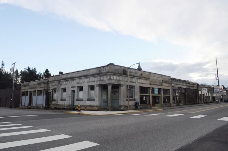
While Tenino retains its historic downtown, now a historic district listed on the National Register of Historic Places, the town serves largely as a "bedroom community", many of its citizens commuting by car to larger cities such as Olympia and Tacoma for work.
Since the mid-1970s, the US Army has used a geographical map of Tenino as a training aid in map reading, due to the variety of symbols represented on the map.
The current mayor of Tenino, Washington is Wayne Fournier. Tenino's first mayor was John Henry Keithahn.
Name origin
Currently historians are unsure of the origin of the name "Tenino" for the town. The name came into use in the 1870s. It is reputedly a Chinook Indian word, meaning "fork in the trail", referring to the site where the Cowlitz Trail between The Columbia River and Puget Sound split, branching to Budd Inlet at Olympia, Washington and Commencement Bay respectively.
Occasionally some assert Tenino was named after either a train locomotive or a railroad survey stake with the numbers 10-9-0. However, avid local historian Art Dwelley, former editor of the Tenino Independent, found no such locomotive or survey marker designations but discovered references to the area as "the tenino" in newspapers predating the arrival of the railroad.
Adding to the mystery, Tenino was historically the collective name of the Warm Springs bands of North-Central Oregon. Also, the Oregon Steam Navigation Company operated a sternwheeler named Tenino on the Columbia River from 1860 to 1876. There are streets named "Tenino" in Portland, Oregon and Dallas, Texas, and two "Tenino Avenues", one in Los Angeles, California, and the other in Boulder, Colorado. What connection there is between these and the town, if any, is unknown.
S.J McCormick's Dictionary of the Chinook Jargon (1st ed. pub. 1852) defines "tenino" as "crevasse; canyon; the vulva". No Chinook-English dictionary gives a single Chinook Jargon word for "fork in the trail" [CJ: t'sugh kopa ooahut], or "a place where the waters divide" [CJ: kah chuck t'sugh]. Period Chinook Jargon lexicographers agree that the Jargon word for "fork" was "lapooshet" (a corruption of the French "la fourchette": fork, and describing the implement only), and that the Chinook word for "split", "divide" or "separate" was "t'sugh" and not "tenino". Tenino ("the canyon", see "The Tenino", above) most probably refers to the route of the old stage route (now US 99) from Olympia southwards which passes through a long narrow valley opening up into the prairie at Tenino.
According to William Bright, Tenino Creek in Jefferson County, Oregon, and Warm Springs Indian Reservation, comes from the Sahaptin placename /tináynu/, while Tenino, Washington, probably comes not from Sahaptin but rather from Chinook Jargon ta-ni-no, meaning "canyon, crevasse, vulva".
Geography
Tenino is located at 46°51′24″N 122°51′01″W (46.856745, -122.850290).
According to the United States Census Bureau, the city has a total area of 1.44 square miles (3.73 km2), all of it land.
2010 census
As of the census of 2010, there were 1,695 people, 691 households, and 440 families residing in the city. The population density was 1,177.1 inhabitants per square mile (454.5/km2). There were 740 housing units at an average density of 513.9 per square mile (198.4/km2). The racial makeup of the city was 90.7% White, 0.2% African American, 0.9% Native American, 1.2% Asian, 0.3% Pacific Islander, 2.1% from other races, and 4.6% from two or more races. Hispanic or Latino of any race were 7.4% of the population.
There were 691 households of which 35.6% had children under the age of 18 living with them, 42.3% were married couples living together, 16.2% had a female householder with no husband present, 5.2% had a male householder with no wife present, and 36.3% were non-families. 28.9% of all households were made up of individuals and 12.4% had someone living alone who was 65 years of age or older. The average household size was 2.45 and the average family size was 3.01.
The median age in the city was 36.8 years. 25.4% of residents were under the age of 18; 7.6% were between the ages of 18 and 24; 27.1% were from 25 to 44; 26.8% were from 45 to 64; and 13% were 65 years of age or older. The gender makeup of the city was 46.7% male and 53.3% female.
2000 census
As of the census of 2000, there were 1,447 people, 575 households, and 396 families residing in the city. The population density was 1,720.3 people per square mile (665.1/km2). There were 615 housing units at an average density of 731.1 per square mile (282.7/km2). The racial makeup of the city was 90.53% White, 0.83% African American, 1.17% Native American, 3.11% Asian, 0.07% Pacific Islander, 1.94% from other races, and 2.35% from two or more races. Hispanic or Latino of any race were 3.80% of the population.
There were 575 households out of which 37.7% had children under the age of 18 living with them, 48.7% were married couples living together, 15.7% had a female householder with no husband present, and 31.0% were non-families. 27.3% of all households were made up of individuals and 13.6% had someone living alone who was 65 years of age or older. The average household size was 2.52 and the average family size was 3.01.
In the city, the age distribution of the population shows 29.8% under the age of 18, 7.6% from 18 to 24, 29.4% from 25 to 44, 18.9% from 45 to 64, and 14.3% who were 65 years of age or older. The median age was 34 years. For every 100 females there were 91.4 males. For every 100 females age 18 and over, there were 89.2 males.
The median income for a household in the city was $34,526, and the median income for a family was $41,208. Males had a median income of $31,058 versus $25,972 for females. The per capita income for the city was $18,244. About 5.0% of families and 9.1% of the population were below the poverty line, including 12.4% of those under age 18 and 9.9% of those age 65 or over.
Historic buildings and structures
There are 26 historic sites in or near Tenino. Following are some of those properties.