
Prominence 572 m (1,877 ft) | Isolation 10.6 km (6.6 mi) Elevation 2,809 m Parent range Lechtal Alps | |
 | ||
Similar Galzig, Roggspitze, Parseierspitze, Stanskogel, Patteriol | ||
Valluga is a 2,809 m (AA) high mountain in the Lechtal Alps. The border between the Austrian states Tyrol and Vorarlberg runs over the summit. It is about 3 km north of the village St. Christoph am Arlberg and the Arlberg Pass.
Contents
Map of Valluga, 6655, Austria
VallugabahnEdit
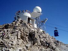
The summit of Valluga is accessible by an aerial tramway called Vallugabahn. This consists of two parts:
Other infrastructuresEdit
In summer 2006 a C-band weather radar operated by Austro Control was installed on top of Valluga.
Valluga hosts some amateur radio infrastructures: a 2-meter band amateur radio repeater (uplink 145.6875 MHz, Downlink 145.0875 MHz) and a packet radio digipeater. Both have a common callsign OE7XVR. Between 2004 and 2010 there was also an amateur television repeater (callsign OE7XSI) with interlinks other repeaters in Austria, Switzerland and Germany.
AscentsEdit
Ascents from alpine club huts:
Ascents from settlements: