
Prominence 375 m | Elevation 2,632 m | |
 | ||
Similar Bretterspitze, Gliegerkarspitze, Wasserfallkarspitze, Marchspitze, Noppenspitze | ||
The Urbeleskarspitze is a 2,632-metre-high mountain peak in the Allgäu Alps. It lies within Austria in the state of Tyrol and is the fifth-highest summit in the Allgäu Alps and the second-highest peak in the Hornbach chain. Its neighbours in the Hornbach chain are the Bretterspitze to the southwest and the Zwölfer Spitze to the northeast.
Contents
- Map of Urbeleskarspitze 6651 Austria
- Urbeleskarspitze
- Rock and structureEdit
- First ascentEdit
- BasesEdit
- AscentEdit
- Literature MapsEdit
- References
Map of Urbeleskarspitze, 6651, Austria
Urbeleskarspitze
Rock and structureEdit
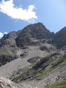
Like most of the high mountains in the Allgäu Alps the Urbeleskarspitze consists of main dolomite. Its summit has a striking bell-shaped appearance and is easily identified from the north and south from nearby and more distant summits.
First ascentEdit
Who first climbed the Urbeleskarspitze cannt be precisely determined. Candidates include unknown locals or a "Dr. Gümbel" in 1854. It was certainly ascended in 1869 by Hermann von Barth.
BasesEdit
The main starting point for ascents is the village of Hinterhornbach in a side valley of the Tyrolean Lechtal. From there it is roughly 2½ hours to the Kaufbeurer Haus, a self-service hut belonging to the DAV. The hut is regularly manned at weekends from Pentecost to early October but is otherwise only open to members of the Alpine Club with a key.
AscentEdit
There is no simple way leading to the summit of the Urbeleskarspitze. The two usable routes from the Kaufbeurer Haus require sure-footedness, a head for heights and Alpine experience and climbing preparedness.
The only partially marked normal route is graded as UIAA II+ and takes just under 2 hours through steep schrofen terrain over the northwest flank to reach the top.
An alternative climb existed over the north arête. It was a UIAA grade II and ran through broken rock, also taking 2 hours to reach the summit of the Urbeleskarspitze.