
Basin countries United Kingdom | ||
 | ||
Similar Lower Rivington Reservoir, Anglezarke Reservoir, Rake Brook Reservoir, Hurst Hill, Great Hill | ||
Upper rivington reservoir
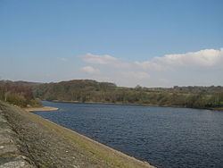
Upper Rivington Reservoir is situated centrally in the Rivington chain of reservoirs, on the West Pennine Moors in Lancashire, England between Rivington and Anglezarke. The engineer for the Rivington reservoirs was Thomas Hawksley and construction took place between 1852 and 1857. The two dams of the Upper Rivington reservoir are the 267 metre Horrobin Embankment that separates it from the lower reservoir and carries a road into the village from the west, and the 332 metre long, 12.2 metre high Yarrow Embankment.
Contents
Map of Upper Rivington Reservoir, United Kingdom
There is an island. A bridleway and residence, The Street are on the side of the reservoir. It is a popular walking destination, between Anglezarke Reservoir to the north, Lower Rivington Reservoir to the south, and Yarrow reservoir to the east.
Street Bottoms and Street Wood were lost with the formation of the reservoir.