
Established 1840 Area 80 ha Postal code 5061 | Postcode(s) 5061 Founded 1840 | |
 | ||
Population 1,402 (2011 census)1,495 (2006 Census)1,303 (2001 Census) Location 5.5 km (3 mi) S of Adelaide | ||
Unley Park is a southern suburb of Adelaide in the City of Unley. Its postcode is 5061.
Contents
Map of Unley Park SA 5061, Australia
It is located on the north side of Cross Road and east of the Belair railway line. Access via public transport is from the Unley Park railway station and the Unley Road "Go Zone".
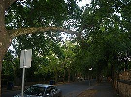
It features Victoria Avenue—Adelaide's wealthiest street, containing many large and luxurious houses built between the two World Wars.
Politically, the suburb is safe for the Liberal; at the 2010 election, the Liberal Party attracted 62.33% of the primary vote at the nearby Hyde Park polling booth.
History
Unley Park Post Office opened on 2 January 1946 and closed in 1999.
Two historic private schools were located on Thornber Street, Unley Park: Kyre College (which was the nucleus of Scotch College) at number 4, and Mrs. Thornber's School, later associated with Tormore House School, at number 39. Both were dissolved early in the 20th Century.