
Designated as world heritage site 1980 | ||
 | ||
Location central Washington state | ||
Umtanum Ridge Water Gap is a geologic feature in central Washington state in the United States. It was designated a National Natural Landmark in 1980.
Contents
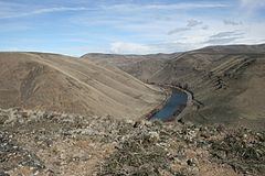
The Umtanum Ridge Water is a water gap cut by the Yakima River through Manastash and Umtanum Ridge anticlines, which are part of the Yakima Fold Belt near the western edge of the Columbia River Plateau located in central Washington. This National Natural Landmark is characterized by a series of steep-sided ridges in the Columbia River basalt which are cut through axially by the Yakima River. It is also referred to as the Yakima River Canyon, and is located between the cities of Ellensburg and Yakima. Washington State Route 821, originally the main route between Ellensburg and Yakima, parallels the river through the canyon.
Geologic history
The great basalt flows of the Columbia Basin and of the Ellensburg Formation, in some places over 5000 meters (17,000 feet) thick, have been folded into ridges (anticlines) and valleys (synclines) running roughly east-west as a result of north-south compression. On its way to join the Columbia River, the Yakima River cuts from the Kittitas Valley southward through four major ridges formed by this compression: the Manastash Ridge, the Umtanum Ridge, the Yakima Ridge, and the Ahtanum Ridge to reach the Yakima Valley.
The highest ridge through which the Yakima flows, the Umtanum Ridge, rises to 983 meters (3225 feet) within 1 km of the river, which lies at about 470 meters (1542 feet) in elevation at the closest point. This unusual juxtaposition (rivers cutting through ridges rather than flowing through apparently more favorable routes) is an example of geologic precedence. The ancient Yakima River is believed to have been there, flowing southward above the relatively flat basalt layers. As the layers compressed, the anticlines slowly rose. The river continued to follow its historic course, cutting downward through the basalt to maintain a relative level. This view is supported by the significant meanders found in the canyon today; when a river has meanders, they tend to be preserved in rock as the river eats into a rising anticline.