
Last eruption Unknown Prominence 1,548 m | Mountain type Complex volcano Elevation 1,548 m | |
 | ||
Similar Ritter Island, Blup Blup, Ambitle, Long Island, Simberi Island | ||
Sea snake attack umboi island png
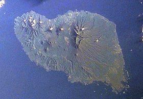
Umboi (also named Rooke or Siassi) is a volcanic island between the mainland of Papua New Guinea and the island of New Britain. It is separated from New Britain by Dampier Strait and Huon Peninsula, New Guinea Island by Vitiaz Strait. It has an elevation of 1,548 metres (5,079 feet). Umboi is a Holocene complex volcano with no historic eruptions. A complex volcano refers to the extensive assemblage of spatially, temporally, and genetically related major and minor volcanic centers with their associated lava and pyroclastic flows.
Contents
Map of Umboi Island, Papua New Guinea
Languages are Papuan Kovai and Austronesian Mbula and Arop-Lokep.
References
Umboi Island Wikipedia(Text) CC BY-SA