
Carries I‑82 / US 395 Width 27.58 ft (8.4 m) (old) | Address Umatilla, OR 97882, USA Materials Steel, Concrete | |
 | ||
Official name Interstate 82Columbia River Bridge Total length 3,308 ft (1,008.3 m) (old)3,433 ft (1,046.4 m) (new) Similar Two Rivers Correctio Institution, Tillicum Inn, Riverside Sports Bar & Lounge, Umatilla Chamber of Comm, Clara Brownell Middle Sc | ||
Drive over umatilla bridge in washington
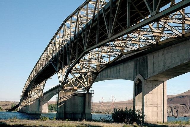
The Umatilla Bridge is the collective name for a pair of bridges in the northwest United States, carrying Interstate 82/U.S. Route 395 across the Columbia River at the Washington/Oregon border. The older bridge opened 62 years ago in 1955 and is a steel through truss cantilever bridge and carries southbound (east on I-82) traffic. Northbound traffic (west on I-82) travels on the newer concrete arch bridge, opened 29 years ago in 1988.
Contents
Pov over umatilla bridge to oregon
Construction
The old bridge was proposed by Umatilla County judge James H. Sturgis and known as "Sturgis' folly" initially. The construction upstream of McNary Dam would create Lake Wallula and submerge the old Wallula Highway. In the interim, traffic was carried across the newly formed lake via ferry service, with 178,576 vehicles transported in 1951. The bridge was financed by $10 million worth of bonds and operated as a toll bridge for 19 years until August 30, 1974, when the bonds were fully repaid.
It is a five-span continuous Warren through truss design. The configuration of the span is unusual in the fact that it takes advantage of a submerged island near the middle of the Columbia River. With its two 600-foot (180 m) spans, each constructed using the cantilever method, this is the only bridge in the state having two spans constructed using that method.