
Opening date 1972 Length 4,927 m Construction cost 1.39 billion INR Impound Tapti River | Status Operational Impounds Tapti River Opened 1971 Construction began 1964 Spillway 22 | |
 | ||
Similar Ukai Thermal Power St, Sardar Sarovar Dam, Wanakbori Thermal Power St, Kadana Dam, Dharoi dam | ||
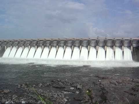
The Ukai Dam, constructed across the Tapti River, is the largest reservoir in Gujarat. It is also known as Vallabh Sagar. Constructed in 1972, the dam is meant for irrigation, power generation and flood control. Having a catchment area of about 62,255 km2 and a water spread of about 52,000 hectares, its capacity is almost same as that of the Bhakra Nangal Dam. The site is located 94 km from Surat.
Contents
Map of Ukai Dam, Gujarat 394680
The storage capacity of Ukai dam is almost 46% of the total capacity of all the other existing dams in Gujarat if put together. Thus it can be concluded that the rest of the dams have as little as 0.1% average storage capacity. During the last 40 years, the actual irrigation potential is attained through all the major and medium water resources projects in the State, which comprises only 14 million hectares.
The dam is an earth-cum-masonry dam. Its embankment wall is 4,927 m long. Its earth dam is 80.77 meters high, whereas the masonry dam is 68.68 meters high. The dam's left bank canal feeds water to an area of 1,522 km2. and its right canal provides water to 2,275 km2 of land.
Surat ukai dam alert
Ukai Hydro Power Station
There are four hydro turbine units, each of 75 MW with a total installed capacity of 300 MW. All the above units were made by BHEL. Commissioning dates of units 1 to 4 are: 8 July 1974, 13 December 1974, 22 April 1975 and 4 March 1976.