
Area 247.6 km² | Website www.city.uda.nara.jp Population 31,274 (1 Apr 2015) | |
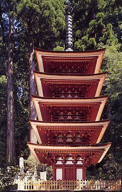 | ||
Time zone Japan Standard Time (UTC+9) Weather 4°C, Wind N at 3 km/h, 94% Humidity Points of interest Murō‑ji, Uda Animal Park うだ, Matabee Sakura, Ōno‑ji, Heiseihaibarakodomonomori Park | ||
Explore22 japan update uda nara
Uda (宇陀市, Uda-shi) is a city located in northeastern Nara Prefecture, Japan.
Contents
- Explore22 japan update uda nara
- Map of Uda Nara Prefecture Japan
- Geography
- Neighboring municipalities
- Rail
- Road
- References
Map of Uda, Nara Prefecture, Japan
The modern city of Uda was established on January 1, 2006, the towns of Haibara, Ōuda and Utano, and the village of Murō (all from Uda District).
As of December 29, 2005, the city had an estimate population of 38,648 and a population density of 155.35 persons per km². As of April 1, 2015, the city has an estimated population of 31,274 and 13,128 households. The population density is 145.64 persons per km², and the total area is 247.62 km².
Each former town became a ward. The wards here are ordinary wards of a city, unlike the 23 special wards of Tokyo.
Geography
Located in the Yamato Plateau in northeastern Nara Prefecture, it is surrounded by mountains in all directions. The Kintetsu Osaka Line has a major role in transportation in Uda.