
South end: US 60 / US 62 Counties: Alexander US 62 IL 62 → | North end: US 51 / US 60 / US 62 US 60 IL 60 → Length 1.48 km | |
 | ||
County Alexander County, Illinois | ||
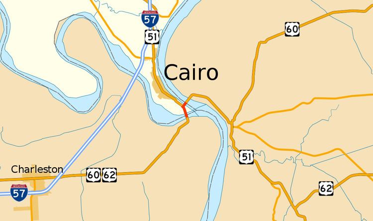
U.S. Route 60 and U.S. Route 62 (US 60/US 62) run for a very short distance within the state of Illinois. They follow the same road for their entire existence within the state. They run around Fort Defiance in Cairo. It runs from the Cairo Mississippi River Bridge over the Mississippi River east to the Cairo Ohio River Bridge over the Ohio River; the Ohio River Bridge also carries US 51. The bridges cross the two rivers just north of the mouth of the Ohio.
Contents
Route description
US 60/US 62 enter Illinois via the Cairo Mississippi River Bridge, a narrow, through truss bridge. The bridge deposits the two highways onto a viaduct which rises above farmland in the alluvial plain. At the northern end of the causeway is the entrance to Fort Defiance Park, a former Civil War military post and later state park. Fort Defiance marks the confluence of the Mississippi and Ohio Rivers and Illinois' southernmost and lowest points. The lone intersection for US 60/US 62 is with US 51, which joins from the north. The three highways come together to head northeast and rise onto the Cairo Ohio River Bridge and into Kentucky.
The Great River Road's National Route overlaps US 60/US 62 from the intersection with US 51 to the Kentucky state line.
History
Until the Mississippi River Bridge opened c. 1929, US 60 used a ferry directly from Bird's Point, Missouri across that river (below the Ohio) to Wickliffe, Kentucky. After that it ran into Cairo and used a ferry from roughly 22nd Street to East Cairo, Kentucky. US 62 was designated around 1930, and the Ohio River Bridge replaced the ferry in 1937.
Originally, the Mississippi River bridge opened in 1929. It was a boom to economies of Southeast Missouri and Northern Arkansas. The toll drivers would have had to pay on the Mississippi bridge was $1.40 (equivalent to $20.07 in 2016).
Meanwhile, the Ohio River bridge was delayed. An Act of Congress gave them more time. It was eventually dedicated on November 11, 1938, and made toll free exactly ten years later. It had a cost of $3 million (equivalent to $249 million in 2015).
Major intersections
The entire route is in Cairo, Alexander County.