
Existed: 1936 – present Constructed 1936 | Length 601.8 km | |
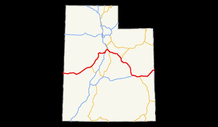 | ||
East end: I-70 / US 6 / US 50 towards Grand Junction, CO | ||
U.S. Route 6 (US-6) is a major east–west state highway through the central part of the U.S. state of Utah. Although it is about 40 miles (64 km) longer than US-50, it serves more populated areas, and in fact follows what had been US-50's routing until it was moved to follow Interstate 70 (I-70) in 1976. In 2009, the Utah State Legislature named part of the route the Mike Dmitrich Highway, which generated controversy, as the state of Utah had previously joined with all the other states through which US-6 passes in naming all of US-6 the Grand Army of the Republic highway.
Contents
Route description
US-6 enters Utah overlapped with US-50 in the Great Basin, a large desert that includes much of western Utah. As part of the Basin and Range Province, the terrain alternates between north–south oriented flat valleys and mountain ranges. US-6 and US-50 cross the Snake Valley, Confusion Range (through Kings Canyon), Tule Valley, House Range (via Skull Rock Pass), and Pahvant Valley (passing north of Sevier Lake), finally reaching the town of Hinckley just before they split in Delta. US-6 turns to the northeast at that city, paralleling the Union Pacific Railroad's Lynndyl Subdivision to the west of the Canyon Mountains, Gilson Mountains, and East Tintic Mountains—three ranges that form the eastern boundary of the Basin and Range Province.
At Tintic Junction, the intersection with SR-36 in the Tintic Valley, US-6 turns east and ascends the East Tintic Mountains. It passes through the mining city of Eureka as it climbs to The Summit, before descending through Homansville Canyon into the Goshen Valley. Although it left behind the UP rail line at Tintic Junction, this part of US-6 parallels the former Tintic Branch of the Denver and Rio Grande Western Railroad, which has been partially abandoned. After passing through Goshen, the highway curves around the north side of Warm Springs Mountain and into the Utah Valley, where it enters Santaquin. On the east side of that city, US-6 begins an overlap with I-15, while the old alignment—SR-198—continues straight through Payson and Salem. After about 13 miles (21 km) together in the Utah Valley, US-6 and I-15 separate in Spanish Fork, the latter turning southeast onto a short two-lane expressway. SR-198 rejoins US-6 on the eastern outskirts of Spanish Fork, and soon thereafter US-89 joins at Moark Junction. The two routes—US-6 and US-89—begin an overlap here that extends through the Spanish Fork Canyon, alongside the UP Provo Subdivision (ex-D&RGW), to Thistle in the Wasatch Range. The remainder of US-6 to the Colorado state line parallels this rail line (which becomes the Green River Subdivision at Helper).
US-6 continues alone through the Spanish Fork Canyon, now alongside Soldier Creek, to Soldier Summit on the Wasatch Plateau, where it finally leaves the Great Basin into the watershed of the Colorado River. It begins to descend by following the White River, which empties into the Price River near Colton. The Price River takes US-6 down through the Price Canyon, the west edge of the Book Cliffs, joining US-191 at Castle Gate. The land flattens and opens out at Helper, named for the helper locomotives needed to carry trains up to Soldier Summit, and US-6 continues southeasterly around Price on a two-lane freeway bypass, with the old alignment marked as both a business route and SR-55. Relatively flat land continues as US-6 parallels the Book Cliffs to the southwest and west, crossing the Price River at Woodside. West of Green River, US-6 joins I-70/US-50, which it overlaps for the remainder of its stay in Utah. Now south of the Book Cliffs, the four routes head east to Crescent Junction, where US-191 splits to the south. As it begins to approach the Colorado River, the highway curves northeasterly through the Grand Valley and into Colorado.
According to the National Highway Traffic Safety Administration, there were 519 fatal and serious injury crashes between Spanish Fork and Green River in Utah from 1996–2008, leading the stretch to be considered one of the deadliest roads in the U.S.
US-6 forms an arch-shaped route with Spanish Fork at the apex. The western half of the arch is the road less traveled, passing through the Great Basin desert, Sevier Lake, Delta, Eureka and the Tintic Standard Reduction Mill.
The eastern half is a popular transportation corridor, paralleling the Denver and Rio Grande Western Railroad's transcontinental line. This half passes over Soldier Summit and the historic railroad hub of Helper.
Starting in the spring of 1983, US-6 was a discontinuous route for almost one year, due to a massive landslide that destroyed the town of Thistle. During this time traffic was routed on two detours. One, via Salina, Utah, was over 200 miles (320 km) long and took traffic almost 100 aerial miles from the route of US-6. The other, via Duchesne, Utah, was shorter. However, this detour traversed steep grades and was not recommended for trucks. The night before the rebuilt US-6 opened, the highway stubs at either side of the landslide were filled with tens of miles of trucks, the drivers tired of the lost revenue from the long detours. The landslide remains the most costly in the history of the United States. Two rest areas along US-6 pay tribute to the residents of the town who lost everything.
US-6 in Utah passes through or by several ghost towns including Tintic, Thistle, Tucker, Soldier Summit, Colton, Woodside and Cisco. Most of these towns were either mining or railroad based.
The 120 miles (190 km) section of US-6 between Spanish Fork and Green River is considered one of the deadliest stretches of highway in the United States. A high volume of trucks and automobiles travel that stretch at interstate speeds, along hairpin turns, through narrow canyons.
History
US-6 did not enter Utah until 1936, when it was extended west from Greeley, Colorado to Long Beach, California. The eastern half in Utah, from Colorado to Spanish Fork, overlapped US-50, but after a short segment on US-91 to Santaquin, it followed a route that was new to the U.S. Highway system into Nevada. This road was not yet built to good standards; while it was improved to Hinckley, the remainder across the desert was a graded earth road. It was not paved all the way until 1952, when a new alignment was completed from Hinckley into Nevada; within a few years, US-50 was moved from a long overlap with US-40 (now I-80) south to the new road, completely overlapping US-6 through Utah. US-50 was moved farther south in 1976, due to the completion of I-70 across the San Rafael Swell, separating the two routes between Delta and Green River.
Utah Valley to Colorado
The road from SR-1 (US-91 by 1926, now US-89) in Spanish Fork southeast via Price and Green River to the Colorado state line became a state highway in 1912, with the final section - Spanish Fork to Colton - being added in May. However, the original route was somewhat longer than present-day US-6, most notably between Price and Green River, where travelers went south from Price to Castle Dale via present SR-10 and then east to Green River via what are now county roads north of the San Rafael River (partly along an old never-used Denver and Rio Grande Railroad grade). Other differences included going southeast from Green River to Valley City and northeast to Thompsons. New construction through Price Canyon between Kyune and Castle Gate was made easier by the presence of the Denver and Rio Grande Railroad in the canyon. Later that year, the Midland Trail Association was organized in Grand Junction, Colorado to promote a transcontinental auto trail that would include this road.
A 1913 law provided state aid to counties to construct the Midland Trail, with a general route defined. Initially it was to follow the present US-6 via Woodside between Price and Green River, but an amendment changed it to the existing state road through Buckhorn Flat (east of Castle Dale). Travelers began using the Midland Trail through eastern Utah in early July 1913, and the road through Price Canyon, replacing a detour via Willow Creek Canyon (US-191) and Emma Park, was completed by the men of Price later that month. A.L. Westgard of the National Highways Association praised the improvements to the road since the previous year, singling out the Price Canyon segment as "almost beyond comprehension". Although it was hoped that it would become part of the Lincoln Highway, the high mountain passes in Colorado convinced that association to designate a route farther north through Wyoming in September 1913. Midland Trail promoters were not discouraged; instead they were determined to continue to improve to the route to make it better than the Lincoln Highway.
The shorter route via Woodside rather than Castle Dale was considered again in 1916, due to problems with maintaining the latter and a new bridge over the Price River at Woodside, and it was adopted as a state road in April. The piece northwest of Sunnyside Junction had already been designated as part of a state road to Sunnyside, the rest of which still exists as SR-123. A cutoff from Springville south to Moark Junction via Mapleton was also added that year.
A 1919 law redefined the state highway system to include only a short list of roads and any federal aid projects. At the urging of Grand County, the route that corresponded to the Midland Trail was realigned to the longer but more scenic road along the Colorado River between Moab and Cisco, including the new Dewey Bridge. In response to a Carbon County request, the law also removed Price Canyon from the route, instead taking it along the older road through Willow Creek Canyon and Emma Park. Finally, the older route from Spanish Fork to Moark Junction was dropped in favor of the 1916 addition from Springville. Four years later, both counties had changed their minds, and the legislature changed the route back. The Moab-Cisco River Road was entirely dropped (though it was redesignated in the early 1930s as SR-128), but both the Price Canyon and Emma Park routes remained. Also that year, the Bureau of Public Roads approved Utah's seven percent federal-aid system in accordance with the Federal Aid Highway Act of 1921, including the Springville-Colorado segment of the Midland Trail.
In the 1920s, the State Road Commission numbered the Springville-Colorado roadway as State Route 8. Several years later, in 1926, it also became part of U.S. Route 50, which continued east to Annapolis, Maryland (west of Thistle, the road was initially not part of US-50; instead it was the north end of US-89, which ended at Spanish Fork, leaving the Moark Junction-Springville road as simply SR-8). The legislature officially adopted the SR-8 designation in 1927, dropping the Emma Park alternate, and designating two other roads as SR-8: the Spanish Fork-Moark Junction road, which had been dropped in 1919, and a branch from Soldier Creek Junction northeast via Nine Mile Canyon to Myton, which had been part of the 1919 system. The Myton spur was split off in 1931 as SR-53, and the Spanish Fork spur became SR-105 in 1945.
The state completely reconstructed US-50 east of Spanish Fork in 1930 and 1931, eliminating most curves and railroad grade crossings, and shortening it by 14 miles (23 km).
Utah Valley to Nevada
The Grand Central Highway was the local name for the road beginning at the Lincoln Highway in Ely, Nevada and running east and northeast through Delta and Eureka to the Arrowhead Trail in Santaquin. Due to its avoidance of the Great Salt Lake Desert that the Lincoln Highway passed through, Ely garage owners were promoting it as the best route to Salt Lake City by May 1921. For the same reason - long stretches of desert - Grand Central Highway promoters believed it to be superior to the Arrowhead Trail for Los Angeles-bound travelers. The Eureka Commercial Club posted a billboard in Santaquin in July, advertising the "shortest and best all year route to California". The Midland Trail Association, whose trail followed the Lincoln Highway's route between Salt Lake City and Ely, adopted the Grand Central as an official alternate route in June 1922. The next year, the state legislature added the road from Santaquin to Silver City (southwest of Eureka) to the state highway system, and in 1925 it was extended to Delta. Along with the road southeast from Delta to Holden, this was designated State Route 26 in 1927, and at the same time the road west from Delta to Nevada was added to the system as State Route 27. (The portion in Nevada became SR 14 in 1925.)
In 1925, during early U.S. Highway system planning, the Grand Central Highway was designated as U.S. Route 50's path across western Utah. However, when the final plan was approved in late 1926, US-50 had a gap between Ely and Thistle. The gap was filled in about 1930 - but via the Wendover Cutoff, far to the north, leaving the Grand Central Highway as only SR-26 and SR-27. The road again received attention in 1932, when the Roosevelt Highway Association was looking for a path for a westward extension of its trail - which had survived the 1920s by being identified with U.S. Route 6 - from Greeley, Colorado to the West Coast. The association tentatively approved a route in April, entering Utah via US-50 to the Utah Valley, and leaving via the Grand Central Highway to Ely. The Delta Lions Club had suggested this alignment for the same reasons that the highway had become popular in the 1920s: cooler weather than the Arrowhead Trail (then US-91). Despite the State Road Commission designating US-40 across the state as the Roosevelt Highway in 1935, the final route, approved by the American Association of State Highway Officials as US-6 in December 1936, followed US-50 and the Grand Central Highway.
However, the designation did not mean that the road would be immediately improved. It was not until September 1952 that paving was completed west of Delta, largely on a new alignment south of the old road. Business Week described the original route as "nothing but a wagon trail-rutted, filled with dust...one of the worst chunks of federal [sic] road in the country." A two-day celebration was held in Delta to mark the occasion.
Dividend was bypassed by a new route through Homansville Canyon in about 1931, and the old route (Dividend Road) initially became a branch of SR-26. It was renumbered State Route 159 in 1945 and deleted from the state highway system in 1969.