
Length 785.4 km | ||
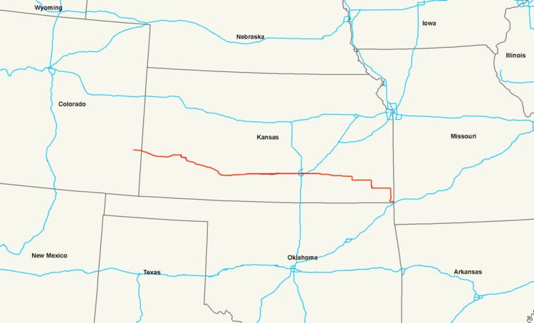 | ||
Existed: 1994 (extended west in 1996) – present States: Colorado, Kansas, Missouri | ||
U.S. Route 400 is a mostly east–west U.S. Highway, commissioned in 1994. The highway's eastern terminus is west of Joplin, Missouri at an intersection with Interstate 44, which it shares with U.S. Route 166. It originally ended in Garden City, Kansas; in 1996 it was extended to its current western terminus in Granada, Colorado at an intersection with U.S. Route 385.
Contents
Map of US-400, United States
Its route number is a "violation" of the usual AASHTO numbering scheme, as there is no "parent" highway named "US 0."
Colorado
US 400 begins in Granada at an intersection with US 385. It then runs concurrently with US 50 through Holly east to the Kansas border.
Kansas
US-400 and US-50 enter Kansas west of Coolidge. They run concurrently through Garden City, where it intersects US-83 and separate at Dodge City, which is where it intersects US-56 and US-283. It continues southeast from Dodge City and first intersects US-54 at Mullinville.
US-400 and US-54 begin a long concurrency at Mullinville which passes through Greensburg, Pratt, and Kingman before entering Wichita. While in Wichita, US-400 and US-54 intersect Interstate 235 and the concurrency of US-81 and Interstate 135. K-96 provides a short freeway connection to Interstate 35, which is also the Kansas Turnpike. At Augusta, US-400 and US-54 enter into another concurrency with US-77, and US-400 breaks from this concurrency at Haverhill.
US-400 continues east through several small towns before turning southeast to go through the Fredonia area and intersecting US-75 at Neodesha. After a brief concurrency with US-75, it turns east, intersecting US-59 near Parsons before intersecting US-69 south of Pittsburg. It then turns south with US-69 and at Crestline, follows US-69A south to Riverton. US-400 then turns east with US-166 at Baxter Springs, and the two highways run concurrently eastward into Missouri.
Missouri
US 400, along with US 166, terminates at I-44 about one mile (1.6 km) east of the Kansas-Missouri state line, three miles (5 km) west of Joplin.
U.S. Route 154
A section of U.S. 400 that ran from Dodge City to Mullinville, Kansas was U.S. Route 154 from 1926 to 1982. It later became K-154 before becoming part of U.S. 400.