
Length 767.7 km | ||
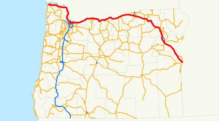 | ||
In the U.S. state of Oregon, U.S. Route 30, a major east–west U.S. Highway, runs from its western terminus in Astoria to the Idaho border east of Ontario. West of Portland, US 30 generally follows the southern shore of the Columbia River; east of Portland the highway has largely been replaced with Interstate 84, though it is signed all the way across the state, and diverges from the I-84 mainline in several towns, as a de facto business route. (The state of Oregon does not sign Interstate business routes; instead it uses the designations US 30 and Oregon Route 99 (along the Interstate 5 corridor) for this purpose.)
Contents
Astoria to Portland
US 30 begins in Astoria, at an intersection with U.S. Route 101. US 101 southbound from the intersection goes down the length of the Oregon Coast, northbound US 101 crosses the Astoria-Megler Bridge into Washington state. US 30 proceeds east through the intersection, through downtown Astoria, and then along the southern bank of the Columbia.
East of Astoria, US 30 is known as the Lower Columbia River Highway No. 2W (see Oregon highways and routes), a designation which it carries until Portland.
Between Astoria and Portland, the highway passes through (or by) numerous Columbia River towns, such as Svensen, Knappa, Wauna, and Westport. In Westport, one can use the Wahkiakum County Ferry to cross the Columbia to Puget Island and Cathlamet, Washington.
Continuing east, the highway passes through the communities of Woodson and Clatskanie. East of Clatskanie, the highway runs inland from the river a bit, approaching the town of Rainier, Oregon.
Just before Rainier is an interchange providing access to the Lewis and Clark Bridge, which crosses the Columbia to Longview, Washington. After Rainier, the highway turns south, following a bend in the river, and runs parallel to Interstate 5 (which is across the river on the Washington side). Towns along the way include Goble, Deer Island, Columbia City, and St. Helens.
South of Deer Island, US 30 becomes an expressway, known locally as St. Helens Road. The highway proceeds through the towns of Warren, Scappoose, and Burlington (as well as passing by the access road to Sauvie Island) before entering Portland. East of Scappoose is the confluence of the Columbia and Willamette Rivers.
Portland area
In northwest Portland, US 30 is sandwiched between Forest Park to the west and the Willamette River to the east. South of the Linnton area, U.S. Route 30 Bypass heads east across the St. Johns Bridge. US 30 continues south along St. Helens Road, then later on Yeon Avenue through an industrial area as it approaches downtown. On the edge of downtown Portland, US 30 briefly becomes a freeway, utilizing part of the route of the cancelled Interstate 505, until its interchange with I-405 at the western end of the Fremont Bridge.
US 30 crosses the Fremont Bridge (along with I-405), on the Stadium Freeway No. 61; at the eastern end of the bridge it joins Interstate 5 south for approximately one mile on the Pacific Highway No. 1 and then joins the Banfield Expressway (I-84), where it becomes the Columbia River Highway No. 2. For the remainder of its route in the Portland area, US 30 shares an alignment with I-84. I-84 passes through the eastern Portland suburbs of Fairview, Wood Village, Gresham, and Troutdale in this fashion.
US 30 Bypass is the Northeast Portland Highway No. 123. It runs along the following streets before rejoining US 30 in Fairview:
N.W. Bridge Street, N. Philadelphia Avenue, N. Ivanhoe Street, N. Richmond Avenue, N. Lombard Street, N.E. Lombard Street, N.E. Portland Highway, N.E. Killingsworth Street, N.E. Columbia Boulevard, and N.E. Sandy Boulevard.
U.S. Route 30 Business is a spur from US 30 Bypass northeast of downtown southwest across I-84/US 30 to Oregon Route 99E east of downtown, just east of the Burnside Bridge. It has not rejoined US 30 on its west end since US 30 was moved onto I-405 and I-5 around downtown.
Former alignment
Before the interstates were built, US 30 ran on Saint Helens Road to the Willamette Heights section of Portland, then on Wardway St, then Vaughn St, then NW 18th & 19th Avenues, then Burnside Street (now BR 30), then Sandy Blvd.
East of Portland
US 30 runs mostly along I-84 in Oregon east of Portland, diverting to short segments of the old surface route to act as a business route or scenic route for I-84:
The sections concurrent with I-84 are part of the Columbia River Highway No. 2 west of U.S. Route 730 at Boardman and part of the Old Oregon Trail No. 6 east of U.S. Route 730.
There is also a U.S. Route 30 Business signed in the Ontario area. This is part of the Olds Ferry-Ontario Highway No. 455.
History
In 1988, U.S. 30 was realigned along NW Yeon Avenue in Portland to alleviate residential congestion. The new route utilized an interchange with I-405 that was intended for a proposed Interstate 505. The proposed interstate was intended to be a 1.44-mile (2.32 km) freeway spur in northwest Portland that would have connected I-405 to St. Helens Road, the latter being the original route for U.S. 30. The freeway was canceled in 1979 after plans were withdrawn, as it would have required condemnation and rerouting streets on a swath of land through the Northwest Industrial neighborhood.