
Length 251 km | Constructed 11 November 1926 | |
 | ||
Existed: November 11, 1926 – present Major cities | ||
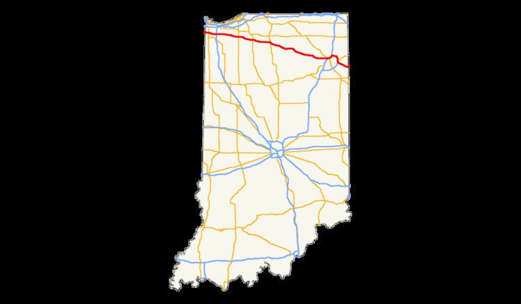
U.S. Route 30 (US 30) is a road in the United States Numbered Highway System that runs from Astoria, Oregon to Atlantic City, New Jersey. In Indiana, the route runs from the Illinois state line at Dyer to the Ohio state line east of Fort Wayne and New Haven. The 155.96 miles (250.99 km) of US 30 that lie within Indiana serve as a major conduit. The entire length of U.S. Route 30 in Indiana is included in the National Highway System (NHS). The highway includes four-lane, rural sections, an urbanized, four-lane divided expressway, and several high-traffic, six-lane areas. First designated as a US Highway in 1926, US 30 replaced the original State Road 2 (SR 2) and SR 44 designation of the highway which dated back to the formation of the Indiana State Road system. A section of the highway originally served as part of the Lincoln Highway. Realignment and construction projects have expanded the highway to four lanes across the state. There are over 40 traffic signals between I-65 at Merrillville and I-69 at Fort Wayne.
Contents
Route description
US 30 enters Dyer from Lynwood, Illinois along the original alignment of the Lincoln Highway, as a four-lane divided highway. At Moeller Street, the roadway becomes a four-lane highway with a center turn lane before reaching an at-grade intersection with CSX railroad tracks. Thereafter, the road returns to four-lane divided highway before a traffic light at US 41 in Schererville and passing under Norfolk Southern railroad tracks. After US 41, the original alignment of the Lincoln Highway leaves US 30 and continues along the same route as old State Road 330 (SR 330). US 30 begins to curve towards the southeast, still as a four-lane divided highway. The highway has a traffic light at SR 55, heading east as the roadway enters Merrillville, where the route becomes a six-lane divided highway and has an interchange at Interstate 65 (I-65). At Colorado Street in Merrillville, the road narrows back to a four-lane divided highway.
After a traffic light at the southern terminus of SR 51 in Hobart, the original alignment of the Lincoln Highway rejoins US 30. The highway passes through a mix of farmland and residential properties on the way to Valparaiso, entering the city and passing through commercial properties. The highway has a traffic light at SR 2 at the western end of the concurrency of the two roads. From there, the road crosses railroad tracks, passes south of Valparaiso University, and has a traffic light at the eastern terminus of SR 130. After passing the traffic light at SR 130, the road has a full interchange with SR 49 and the eastern terminus of the SR 2 and US 30 concurrency. Continuing east, the road passes the Porter County Municipal Airport and proceeds east-southeast from Valparaiso, towards Plymouth. Along this segment, US 30 passes through rural farmland, with an intersection at US 421 and an at-grade railroad crossing with the Chesapeake and Indiana Railroad. East of the railroad tracks is an intersection with SR 39 and an interchange at US 35.
US 30 runs along the north side of Plymouth, passing through an interchange with the northern terminus of SR 17 and near the Plymouth Municipal Airport. The route curves around the northeast side of the city, having an interchange with US 31 and heading southeast towards Warsaw. At Bourbon, the highway has an interchange with SR 331. The road curves east before entering Warsaw and has an interchange with SR 15, south of the Warsaw Municipal Airport. After passing the airport, the road enters a mix of commercial and residential properties and has a traffic light at an old alignment of the Lincoln Highway, before passing north of Winona Lake and heading towards Columbia City. At Columbia City, the road turns southeast and has traffic lights at SR 109, SR 9, and SR 205. After SR 205, US 30 heads east towards Fort Wayne, paralleling the Chicago, Fort Wayne and Eastern Railroad. The route crosses into Allen County at a traffic light at County Line Road.
The highway enters Fort Wayne with a traffic light at Kroemer Road and a trumpet interchange with US 33, at the western terminus of US 33's concurrency with US 30, and proceeds east-southeast towards an interchange with I-69 as a six-lane divided highway. At the diamond interchange with I-69, US 33 runs south on I-69, while US 30 continues north, concurrent with both I-69 and US 24; the road itself continues east as SR 930 and as Goshen Road. US 30's concurrency with I-69 is a six-lane urban interstate with interchanges at Lima Road (US 27 and SR 3) and Coldwater Road (formerly SR 327 and US 27). At the interchange of I-69 and I-469, US 30 heads east concurrent with I-469 around the north and east sides of Fort Wayne, towards New Haven. The highway is a four-lane interstate passing through a mix of farmland and residential properties. Proceeding east, the interstate crosses the St. Joseph River and has an interchange at Maplecrest Road before turning south around the northeast side of Fort Wayne to subsequent interchanges with SR 37 followed by US 24. After the US 24 interchange, the highway crosses the Maumee River and Norfolk Southern railroad tracks before leaving I-469 east of downtown New Haven at the eastern terminus of SR 930. After I-469, US 30 heads southeast away from New Haven, passing through rural farmland as a four-lane divided highway. The route has an intersection at SR 101 before entering Ohio, heading toward Van Wert.
The entire length of U.S. Route 30 in Indiana is included in the National Highway System (NHS), a network of highways that are identified as being most important for the economy, mobility and defense of the United States. The highway is maintained by the Indiana Department of Transportation (INDOT), similar to all other U.S. Highways in the state. The department tracks the traffic volumes along all state highways as a part of its maintenance responsibilities using a metric called average annual daily traffic (AADT), calculated along a segment of roadway for any average day of the year. In 2010, INDOT figured that lowest traffic levels were 10,870 vehicles and 4,750 commercial vehicles used the highway daily between US 31 and SR 331. The peak traffic volumes were 69,280 vehicles and 12,660 commercial vehicles AADT along the section of US 30 that is concurrent with I-69, between the Lima Road and Coldwater Road exits in Fort Wayne.
History
The Lincoln Highway was planned in 1913 to run west to east across Indiana, including to South Bend and Fort Wayne. In 1915, the highway opened and passed through downtown Fort Wayne on its route through Indiana, and was assigned the designation of Main Market route number 2 in 1917. Further designations saw the route become SR 2 from the Illinois state line to Valparaiso, SR 44 Valparaiso to Fort Wayne and SR 2 from Fort Wayne to the Ohio state line. In the early 1920s, the Lincoln Highway was moved south between Valparaiso and Fort Wayne, to what is now known mostly as Old US 30, passing through Plymouth and Warsaw. A section of US 30 in Dyer known as the "ideal section" of the Lincoln Highway was opened in 1923 and rebuilt in the 1990s. In 1924, the sections of the road that were part of the original Lincoln Highway was paved, followed by the paving of the rest of US 30, which was commissioned in 1926. In 1927, a small realignment between Hanna and SR 29 (current US 35) took place. During the 1950s, US 30 in Fort Wayne was rerouted to Coliseum Boulevard, constructed as a "circumurban" highway to bypass Fort Wayne. In 1998, US 30 in Fort Wayne was again rerouted onto I-69 and I-469, bypassing most of Fort Wayne and New Haven on the north and east side of the two towns. The Coliseum Boulevard routing was assigned the SR 930 designation as a result, when INDOT could not give the route over to local control.