
Existed: 1926 – present Constructed 1926 | Length 377.9 km | |
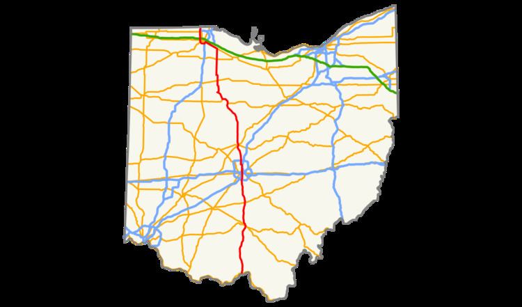 | ||
U.S. Route 23 (US 23) is a United States Numbered Highway that runs from Jacksonville, Florida, to Mackinaw City, Michigan. In the state of Ohio, it is a major north–south state highway that runs from the Kentucky border at Portsmouth to the Michigan border at Sylvania.
Contents
Route description
The route crosses over the Ohio River via the U.S. Grant Bridge into the city of Portsmouth. Through downtown Portsmouth, it follows parallel one-way streets with northbound traffic on Gay Street and southbound on Chillicothe Street. These roads merge into Scioto Trail, which becomes a divided highway north of Rosemount, and again north of Lucasville, through Piketon to just south of Waverly.
Within Waverly, the route becomes concurrent with SR 104, in addition to a four-block concurrency with SR 335 that ends in downtown Waverly. The concurrency with State Route 104 ends just south of Chillicothe, Ohio, at which point US 23 becomes an expressway. The route bypasses Chillicothe to the east, including a short concurrency with US 35 before once again becoming a divided highway near Kingston. It continues as such through Circleville to the southern edge of Columbus, at the southern junction of Interstate 270.
Columbus
In downtown Columbus, the route is applied to a one-way pair. It first jogs easterly via Livingston Avenue (north) and Fulton Street (south) before continuing northerly with northbound traffic on Fourth Street and southbound traffic on Third Street, which becomes Summit Street north of Fifth Avenue. The one-way pair ends at Hudson Street on the border of the SoHud and Glen Echo neighborhoods, with both directions of US 23 jogging westerly onto Hudson Street before continuing northerly on Indianola Avenue, closely paralleling Interstate 71. The route then moves westerly again via Morse Road, then north again onto High Street on the north edge of the East Beechwold neighborhood. North of the northern junction with Interstate 270, High Street becomes Columbus Pike.
The section immediately north of the northern junction with Interstate 270 was upgraded with a northbound-only set of express lanes which passes under Dimension Drive, Campus View Boulevard, Radio City Boulevard, and Flint Road, with the former alignment of US 23 providing access to those roads. This configuration, known as the "Trench", opened to traffic in September 2015, and its construction coincides with a reconfiguration of the I-270 exit.
North of Columbus
In Lewis Center, US 23 once again becomes an expressway, and remains as such until Carey, except for a small portion north of Delaware. Between Marion and Carey, all junctions with other routes are exits, except for SR 529 east of Marion and SR 294 east of Harpster. The route becomes concurrent with US 42 along an eastern bypass of Delaware, then bypasses Waldo and Marion to the east. It bypasses Upper Sandusky to the east and north, mostly in concurrency with US 30. The route then departs the expressway at Carey, becoming concurrent with SR 103 while the expressway continues westerly as SR 15. Within Carey, the concurrency with State Route 103 ends, and a concurrency with SR 199 begins. The two co-signed routes continue as a rural highway to Fostoria, Ohio.
Within Fostoria, US 23 becomes concurrent with SR 18 while turning westerly along Lytle Street, then northerly along a short, unnamed expressway in concurrency with SR 12. At the northern end of the expressway, State Route 12 departs while US 23, still concurrent with State Routes 18 and 199, continues westerly along Tiffin Street, then northerly along County Line Street. State Routes 18 and 199 both depart within Fostoria city limits, while US 23 continues northerly and becomes Fostoria Road. Northeast of Bradner, the route has a junction with US 6.
Northwest of Woodville, the route becomes concurrent with US 20, with both routes continuing northwesterly to Perrysburg. There, US 23 begins a brief wrong-way concurrency with I-75, then departs for a concurrency with Interstate 475, the western bypass of the Toledo metropolitan area. US 23 and I-475 are concurrent for the latter route's entire north-south portion, until I-475 departs in Sylvania to become an east-west aligned route. US 23 then continues northerly into Michigan as a freeway.
History
Before the establishment of the United States Numbered Highway System in 1926, the route of what would eventually become US 23 was numbered as SR 4 from Portsmouth to Marion; SR 22 from Marion to Carey; SR 63 from Carey to Fostoria; SR 199 from Fostoria to Millbury; and SR 2 from Millbury to Toledo. Over the years, portions of US 23 have been realigned to divided highway, freeway, or expressway portions. Among these are a bypass of Circleville built in 1958; the Marion-to-Carey expressway routing, on which work began in 1962; and a bypass of Chillicothe, on which work began in 1966.
When first established, US 23 followed its current routing from Fostoria to Woodville, then continued north along present-day Fostoria Road into Millbury, and northwest along present-day Ohio State Route 51 (Woodville Road) into East Toledo. There, it followed East Broadway Avenue, Starr Avenue, and Main Street to the Cherry Street Bridge (now the Martin Luther King Bridge) across the Maumee River. The route then followed Cherry Street (present-day SR 120) to Detroit Avenue (US 24), before turning west onto Laskey Road and north onto Lewis Avenue. Only a year later, the Fostoria-to-Toledo routing was shifted westerly, taking a northwest-southeast route that was originally designated SR 63 between Fostoria and Perrysburg, then East River Road into Toledo. It crossed the Maumee River via the Fassett Street Bridge, then followed South, Sumner, Logan, Summit, and Huron streets to rejoin its original routing. The Fostoria-to-Millbury routing was designated SR 199, and the Millbury-to-Toledo routing became SR 102, which in turn became present-day SR 51 in 1955. By 1940, US 23 was shifted westerly again in Toledo, taking the Anthony Wayne Bridge to Summit Street, then to Jefferson Avenue and Collingwood Boulevard before rejoining the previous routing.
US 23 was realigned c. 1960 to follow Monroe Street northwesterly out of Toledo, joining with the first constructed segment of its current freeway routing in Sylvania. The freeway was extended southerly to US 20 (Central Avenue) by 1964. By 1969, the entire western freeway bypass of Toledo was complete, carrying the current routings of both US 23 and I-475. In addition, US 23 and SR 199 were swapped north of Fostoria in 1969, with US 23 reverting to its pre-1927 routing between Fostoria and Woodville, then becoming concurrent with US 20 from there to Perrysburg; the 1927-1969 routing of US-23 between Fostoria and Perrysburg thus became part of SR 199.