
Formed August 27, 1962 Fatalities 434 total | Dissipated September 1, 1962 Highest winds 175 km/h | |
 | ||
Lowest pressure 953 hPa (mbar); 28.14 inHg Date 27 August 1962 – 1 September 1962 Similar 1962 Pacific typhoon s, Typhoon Hope, Typhoon Ellen, Typhoon Rose, 1937 Great Hong Kong typhoon | ||
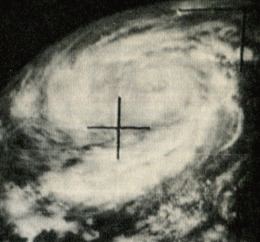
Typhoon Wanda was the most intense tropical cyclone on record in Hong Kong. It was the 59th disturbance in the record-breaking 1962 Pacific typhoon season, forming in August east of the Philippines. Typhoon Wanda reached peak winds of 175 km/h (110 mph) in the South China Sea, and it made landfall on Hong Kong on September 1, producing gusts of 261 km/h (161 mph) which, in combination with a high storm surge, damaged thousands of huts and left 72,000 people homeless. Wanda left a total of 434 deaths, and it is estimated that an identical typhoon striking today would cause HK$2.6 billion ($335 million USD) in losses.
Contents
Meteorological history
The precursor disturbance to Typhoon Wanda was first observed on August 23 near Pohnpei in the Federated States of Micronesia. That day, a circulation formed in the interaction between the Mid-Pacific trough and an easterly wave, with energy from a surge in the Easterlies in the Southern Hemisphere. Initially winds were very weak, and it tracked west-northwestward while slowly gaining intensity. The official track from the Japan Meteorological Agency (JMA) indicated the system first developed into a tropical cyclone on August 25, whereas the Joint Typhoon Warning Center (JTWC) initiated advisories two days later, after it was observed by the Hurricane Hunters. It was designated Tropical Depression 59 while located about 1120 km (700 mi) northeast of the Philippines.
Throughout most of its duration, the cyclone maintained a general west-northwest track, although initial forecasts had a northward bias that anticipated a track into Taiwan. On August 28, reconnaissance aircraft reported winds of 75 km/h (45 mph), or tropical storm status; as such, the JTWC named the system Wanda. Throughout the day, Wanda quickly intensified, with the pressure dropping to 992 mbar and the winds reaching 110 km/h (70 mph) by the end of the day. The next day, Wanda attained typhoon status, and on August 30 it traversed the Luzon Strait between the Philippines and Taiwan. By that time, the typhoon was about 1600 km (1000 mi) wide, and the next day rainbands began affecting southeastern China and Hong Kong.

While approaching southeastern China, Wanda reached its peak strength of 175 km/h (110 mph), with reconnaissance aircraft reporting a minimum pressure of 960 mbar. The typhoon weakened slightly before making landfall on Hong Kong at 0000 UTC on September 1, with winds of 150 km/h (90 mph). A combination of cold air and land interaction caused Wanda to weaken rapidly, and the JTWC discontinued advisories about 18 hours after Wanda moved ashore. According to the JMA track, the system turned southwest into the Gulf of Tonkin, intensifying slightly before shifting southeastward and dissipating over Hainan on September 4.
Typhoon Wanda was fairly well-forecasted, compared to other storms during the year. The average forecast error for 24 hours was about 260 km (160 mi), whereas for 48 hours, it was 415 km (255 mi); both values were less than the seasonal average.
Impact
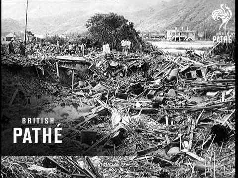
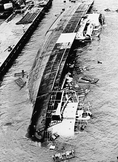
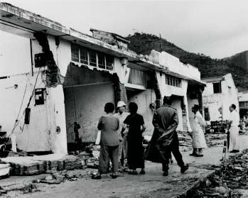
During its passage of Hong Kong, Wanda produced 263 mm (10.4 in) of rainfall. The typhoon moved ashore during the daily high tide, resulting in a storm surge of at least 5 m (17 feet) above normal, especially around Tolo Harbour, which caused widespread flooding and damaged or destroyed thousands of huts and houses in Shatin and Taipo. The strong winds and waves blew fishing vessels from the water onto the streets. Maximum sustained winds were 145 km/h (90 mph 10-minute sustained), while gusts reached 260 km/h (161 mph), stronger than any previous typhoon on record. Additionally, the lowest pressure during its passage was 953.2 mbar, which was the lowest on record at the RHKO.
Overall, the typhoon caused 434 deaths and left 72,000 people homeless. There was never a finalized damage total, although it was estimated in the millions of dollars. Over 2,000 boats in the colony were either wrecked or damaged. As damage was so severe in Hong Kong, there were little reports of impact elsewhere, although the storm did move across portions of southern China. It is estimated that a storm identical to Wanda would cause HK$2.6 billion ($335 million USD) in losses if it were to strike today. In view of the damages suffered in this storm, land in Shatin and Taipo were reclaimed to 3m higher above sea level than other areas of Hong Kong during the development of the New Towns.