
Formed October 30, 2014 Fatalities None | Dissipated November 7, 2014 Damage Minimal | |
 | ||
Highest winds 10-minute sustained: 205 km/h (125 mph)1-minute sustained: 285 km/h (180 mph) Lowest pressure 910 hPa (mbar); 26.87 inHg Date 30 October 2014 – 7 November 2014 Similar Typhoon Vongfong, Hurricane Genevieve, Tropical Storm Lingling, Typhoon Phanfone, Tropical Storm Hagibis | ||
Typhoon Nuri, known in the Philippines as Typhoon Paeng, was the third most intense tropical cyclone worldwide in 2014. Nuri developed into a tropical storm and received the name Paeng from the PAGASA on October 31, before it intensified into a typhoon on the next day. Under excellent conditions, especially the synoptic scale outflow, Nuri underwent rapid deepening and reached its peak intensity on November 2, forming a round eye in a symmetric CDO. Having maintained the impressive structure for over one day, the typhoon began to weaken on November 4, with a cloud-filled eye.
Contents
Because of increasing vertical wind shear from the mid-latitude westerlies, Nuri lost the eye on November 5, and deep convection continued to diminish. The storm accelerated northeastward and completely became extratropical on November 6. However, on November 7, Nuri’s circulation split, and the new center absorbed the storm.
Meteorological history
A low-pressure area formed approximately 590 km (365 mi) east-southeast of Guam early on October 28, and a tropical disturbance formed within the area on the next day. After having slowly consolidated for two days, the Joint Typhoon Warning Center (JTWC) issued a Tropical Cyclone Formation Alert to the system on October 30, for its quickly consolidating but broad low-level circulation center (LLCC) under a favorable environment. Additionally, the Japan Meteorological Agency (JMA) upgraded the low-pressure area to a tropical depression at noon on the same day. The agency upgraded the system to a tropical storm and named it Nuri early on October 31, shortly after the JTWC upgraded it to a tropical depression and designated it as 20W. Under low vertical wind shear and good outflow, a central dense overcast (CDO) started to flare over the LLCC with the tighter wrapped banding, prompting the JTWC upgrading Nuri to a tropical storm in the afternoon. As it entered the Philippine Area of Responsibility, the PAGASA named it Paeng at 23:00 PST (15:00 UTC).
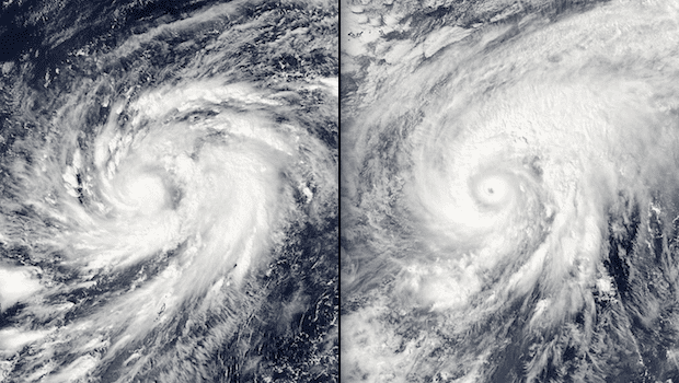
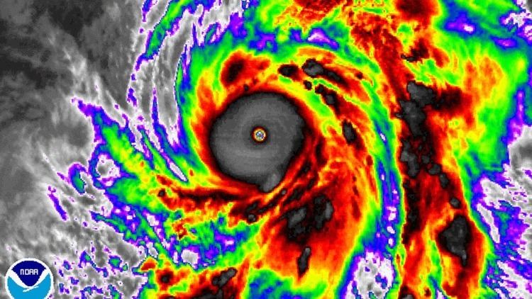
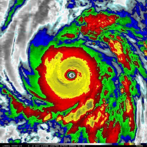
On November 1, Nuri was upgraded to a severe tropical storm at 00:00 UTC and a typhoon at noon by the JMA, when the system was turning northward and forming a microwave eye beneath the compact CDO. Late on the same day, Nuri began to form an eye, so the JTWC upgraded it to a typhoon. The system underwent rapid deepening on November 2, depicting a highly round and sharply-outlined 15 nautical miles (28 km; 17 mi) eye embedded in a symmetric CDO of super-deep convection. It also developed its own mesoscale anticyclone that, in combination with the synoptic scale poleward and equatorward outflow, was providing an extremely efficient ventilation to the associated convection. Thus, the JMA reported that Nuri had reached peak intensity with ten-minute maximum sustained winds at 205 km/h (125 mph) and atmosphere pressure at 910 hPa (26.87 inHg), when it was located about 520 km (325 mi) southwest of Okinotorishima. The JTWC upgraded Nuri to a super typhoon at the same time, and the warning center even indicated that its one-minute maximum sustained winds had reached 285 km/h (180 mph) six hours later, unofficially recognizing it the most intense tropical cyclone in 2014, tied with Typhoon Vongfong and Typhoon Hagupit.
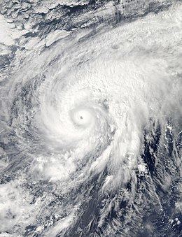
Initially, the JTWC forecast that Nuri would become a record-breaker as strong as Typhoon Haiyan; however, it failed to intensify further. The system retained its impressive structure and turned northeastward along the western periphery of a subtropical ridge to the east on November 3, yet the JTWC indicated that it had begun to gradually weaken owing to warming cloud top temperatures in the afternoon. Early on November 4, the JMA reported that Nuri had started to weaken, and the JTWC downgraded the system to a typhoon. Although vigorous poleward outflow into a jet located to the northeast of the system offset increasing westerly moderate vertical wind shear, it continued undergoing an eyewall replacement cycle, resulting a cloud-filled eye before noon. Nuri still retained tightly-curved banding wrapping into a well-defined LLCC; however, on November 5, the LLCC began to unravel as the deep convection had become isolated to the northern semi-circle, although a weak microwave eye feature remained present. Vigorous poleward outflow into the mid-latitude westerlies became only partially offsetting the increasing vertical wind shear.
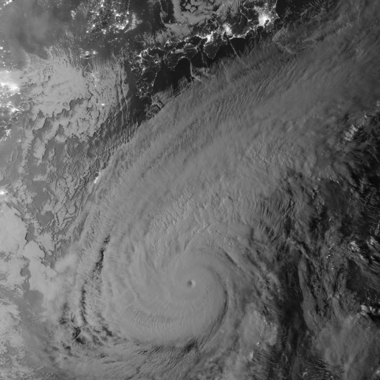
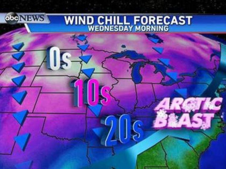
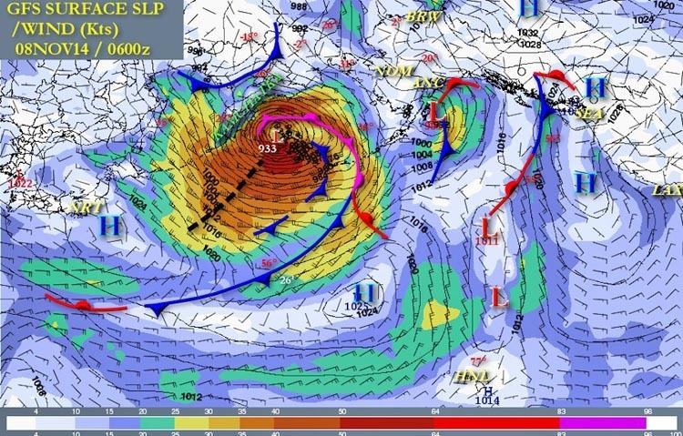
Right after the JMA downgraded Nuri to a severe tropical storm at 00:00 UTC on November 6, the JTWC downgraded it to a tropical storm and issued the final warning for the system, due to the extratropical transition and diminishing deep convection. In the afternoon, Nuri accelerated northeastward and became completely extratropical east of Japan. Thanks to the unusually powerful North Pacific jet stream, the extratropical cyclone underwent extremely explosive cyclogenesis on November 7, owing to the energy from differences in air masses. The system split into two centers early on the same day, yet the former center on the southwest was absorbed into the new center on the northeast within a half a day. The resulting system became one of the most intense extratropical cyclones of the North Pacific Ocean since reliable records and indirectly contributed to below-average temperatures in North America.
Japan
Yoshihide Suga, the Chief Cabinet Secretary of Japan, said that the government of Tokyo would not allow Chinese coral poaching vessels to come ashore when Typhoon Nuri was approaching the area off the Bonin Islands and the Izu Islands. Many of the vessels that had swarmed off the remote islands began leaving the area in a southeasterly direction on November 5, as the Coast Guard patrol ships warned them to go south to get out of the typhoon’s path. However, after Nuri left the area of the Tokyo remote islands, the Chinese coral poaching vessels returned.