
Airport type Public 8/26 5,531 Code TNP Phone +1 760-247-2371 | Elevation AMSL 1,888 ft / 575 m 5,531 1,686 Elevation 575 m | |
 | ||
Owner County of San Bernardino Address 78569 Twentynine Palms Highway, Twentynine Palms, CA 92277, USA | ||
Fsx 29palms twentynine palms airport
Twentynine Palms Airport (IATA: TNP, ICAO: KTNP, FAA LID: TNP) is a public use airport located six nautical miles (11 km) east of the central business district of Twentynine Palms, a city in San Bernardino County, California, United States. It is owned by the County of San Bernardino.
Contents
- Fsx 29palms twentynine palms airport
- 29palms scenery design twentynine palms airport ktnp for x plane 10
- History
- Facilities and aircraft
- References
29palms scenery design twentynine palms airport ktnp for x plane 10
History
Activated on 1 January 1942 by the United States Army Air Forces. Started as USAAF contract glider training - Twenty-Nine Palms Air Academy until 16 February 1943. Had four axillary airfields in local area. Flying training was performed with Fairchild PT-19s as the primary trainer. Also had several PT-17 Stearmans and a few P-40 Warhawks assigned. Conducted basic flying training from March 1943 until transferred to United States Navy April 1944; Under USN control became an axillary airfield to NAS San Diego.
Facilities and aircraft
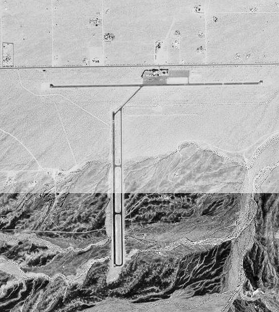
Twentynine Palms Airport covers an area of 480 acres (190 ha) at an elevation of 1,888 feet (575 m) above mean sea level. It has two asphalt paved runways: 8/26 is 5,531 by 75 feet (1,686 x 23 m) and 17/35 is 3,797 by 50 feet (1,157 x 15 m).
For the 12-month period ending February 16, 2006, the airport had 18,000 aircraft operations, an average of 49 per day: 97.% general aviation and 3% military. At that time there were 16 aircraft based at this airport: 68% single-engine, 6% multi-engine and 25% glider.