OS grid reference TG4170508020 Post town NORWICH | Sovereign state United Kingdom Postcode district NR13 | |
 | ||
Tunstall is a village within the civil parish of Halvergate (where the population is included) in the Broadland district of Norfolk, England. It lies some 14 miles (22.5 km) south-east of Norwich alongside the River Bure.
Map of Tunstall, Norwich, UK
The ruinous mediaeval parish church of St Peter and St Paul is a grade II* listed building. Although repaired 1705 and extended in 1853, only the chancel is now usable. According to local legend, the church's bells were stolen by the Devil. He plunged with them into a nearby boggy pool, whence their tolling can occasionally be heard.
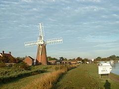
The Stracey Arms Windpump was once used to drain the surrounding marshland into the River Bure. A grade II* listed building, it is now maintained by the Norfolk Windmills Trust and is a visitor attraction.
