
Listing Ultra Topo map IGM, CT-ÑIV-D1 Elevation 5,023 m Prominence 1,554 m | Last eruption 2014 First ascent 1873 | |
 | ||
Translation Throat of fire (Quechua) Similar | ||
Tungurahua volcano eruption 1930s ecuador travelogue movie 50064
Tungurahua, (/tʊŋɡʊˈrɑːwə/; from Quichua tunguri (throat), rahua (fire): "Throat of Fire" or from Panzaleo) is an active stratovolcano located in the Cordillera Oriental of Ecuador. The volcano gives its name to the province of Tungurahua. Volcanic activity restarted on August 19, 1999, and is ongoing as of 2013, with several major eruptions since then, the last starting on 1 February 2014.
Contents
- Tungurahua volcano eruption 1930s ecuador travelogue movie 50064
- Map of Tungurahua Ecuador
- Erupting volcano tungurahua in ecuador
- Etymology
- Location
- Glacier
- Volcanism
- Historical volcanic activity
- Recent volcanic activity
- First ascent
- References
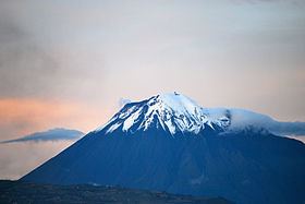
Map of Tungurahua, Ecuador
Erupting volcano tungurahua in ecuador
Etymology
According to one theory the name Tungurahua is a combination of the Quichua tunguri (throat) and rahua (fire) meaning "Throat of Fire". According to another theory it is based on the Quichua uraua for crater. Tungurahua is also known as "The Black Giant" and, in local indigenous mythology it is allegedly referred to as Mama Tungurahua ("Mother Tungurahua").
Location
Tungurahua 5,023 metres (16,480 ft) is located in the Cordillera Oriental of the Andes of central Ecuador, 140 kilometres (87 mi) south of the capital Quito. Nearby notable mountains are Chimborazo (6,310 metres (20,700 ft)) and El Altar (5,319 metres (17,451 ft)). It rises above the small thermal springs town of Baños de Agua Santa (1,800 metres (5,900 ft)) which is located at its foot 8 kilometres (5.0 mi) to the north. Other nearby towns are Ambato (30 kilometres (19 mi) to the northwest), Baños and Riobamba (30 kilometres (19 mi) to the southwest). Tungurahua is part of the Sangay National Park.
Glacier
With its elevation of 5,023 metres (16,480 ft), Tungurahua just over tops the snow line (about 4,900 metres (16,100 ft)). Tungurahua's top is snow-covered and did feature a small summit glacier which melted away after the increase of volcanic activity in 1999.
Volcanism
Today's volcanic edifice (Tungurahua III) is constructed inside its predecessor's (Tungurahua II) caldera which collapsed about 3000 (±90) years ago. The original edifice (Tungurahua I) collapsed at the end of the Late Pleistocene.
Historical volcanic activity
Tungurahua's eruptions are strombolian. They produce andesite and dacite. All historical eruptions originated from the summit crater and have been accompanied by strong explosions, pyroclastic flows and sometimes lava flows. In the last 1,300 years Tungurahua entered every 80 to 100 years into an activity phase of which the major have been the ones of 1773, 1886 and 1916–1918.
Recent volcanic activity
In 2000, after a long period of quiescence, the volcano entered an eruptive phase that continues to this day (as of April 2014). The renewed activity in October 1999 produced major ashfall and led to the temporary evacuation of more than 25,000 inhabitants from Baños and the surrounding area Activity continued at a medium level until May 2006, when activity increased dramatically, culminating in violent eruptions on 14 July 2006 and 16 August 2006. The 16 August 2006 eruption has been the most violent since activity commenced in 1999. This eruption was accompanied by a 10 kilometres (6.2 mi) high ash plume which spread over an area of 740 by 180 kilometres (460 by 110 mi), depositing ash and tephra to the southwest of the volcano. Several pyroclastic flows were generated that killed at least five people, and destroyed a number of hamlets and roads on the eastern and northwestern slopes of the volcano.
A further eruption and evacuation occurred on 4 December 2010. Ecuador's National Agency of Risk Control issued a "red alert", later downgraded to orange. The Ecuadorean Institute for Geophysics reported a rapid increase in seismic activity, a number of explosions and an ash cloud reaching 2 kilometres (1.2 mi) in height. Another eruption occurred on 18 December 2012 forcing evacuation of those living on the volcano's slopes. The volcano erupted again in July 2013. On 1 February 2014, the volcano erupted again.
The volcano erupted Friday 26th of February, 2016, at 12.00 midday, shooting an ash cloud 5,000 metres (16,000 ft) into the air. It is still erupting regularly as of Thursday 4th March 2016.
First ascent
During their seven-year-long South America expedition (1868 to 1876), the German volcanologists Alphons Stübel and Wilhelm Reiss climbed Cotopaxi (Reiss with Angel Escobar; 28 November 1872) and Tungurahua (Stübel with Eusebio Rodríguez; 9 February 1873).