
Length 9.5 km (5.9 mi) Area 26 km² | Width 6.5 km (4.04 mi) Administrative subdivision Tuamotus Island group Tuamotus | |
 | ||
Tuanake or Mata-rua-puna is a small atoll of the Tuamotu Archipelago in French Polynesia. It is located 24 kilometres (15 miles) southwest of Makemo Atoll's westernmost point.
Contents
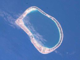
Map of Tuanake, French Polynesia
Tuanake Atoll is roughly semicircular in shape. It measures 9.5 kilometres (5.9 miles) in length with a maximum width of 6.5 kilometres (4.0 miles) . There are some narrow islands on the northern side of its reef with a total land area of about 3 square kilometres (1.2 square miles). Its lagoon is connected to the ocean by a pass located in the southern part of the ringing reef.
Tuanake is located only 7.5 kilometres (4.7 miles) to the northwest of Hiti Atoll. The small group formed by Tuanake, Tepoto Sud and Hiti is also known as the "Raevski Atolls".
History
The first recorded European to sight Tuanake was Russian explorer Fabian Gottlieb von Bellingshausen in 1820.
Administration
Tuanake belongs to the commune of Makemo, which consists of the atolls of Makemo, Haraiki, Marutea Nord, Katiu, Tuanake, Hiti, Tepoto Sud, Raroia, Takume, Taenga and Nihiru. Tuanake Atoll is permanently uninhabited.
Flora and fauna
The Tuamotu reed warbler and the Polynesian ground dove are found in this atoll.