
Start date 1851 | ||
The Fort Laramie Treaty of 1851 was signed on September 17, 1851 between United States treaty commissioners and representatives of the Cheyenne, Sioux, Arapaho, Crow, Assiniboine, Mandan, Hidatsa, and Arikara Nations. The treaty is an agreement between nine more or less independent parties. The treaty set forth traditional territorial claims of the tribes as among themselves. The United States acknowledged that all the land covered by the treaty was Indian territory and did not claim any part of it. The boundaries agreed to in the Fort Laramie treaty of 1851 would be used to settle a number of claims cases in the 20th century. The Native Americans guaranteed safe passage for settlers on the Oregon Trail and allowed roads and forts to be built in their territories in return for promises of an annuity in the amount of fifty thousand dollars for fifty years. The treaty should also "make an effective and lasting peace" among the eight tribes, each of them often at odds with a number of the others.
Contents
Background
Although many European and European-American migrants to western North America had previously passed through the Great Plains on the Oregon and Santa Fe Trails, the California gold rush beginning in 1848 greatly increased traffic. The next year, both Thomas Fitzpatrick (agent of Upper Platte and Arkansas) and David D. Mitchell (superintendent at Saint Louis) recommended a council with the Indians to prevent a conflict. The United States government undertook negotiations with the Native American Plains tribes living between the Arkansas and Missouri rivers to ensure protected right-of-way for the migrants. The Congress had appropriated one hundred thousand dollars to the assembly, endorsed by Luke Lea (the Commissioner of Indian Affairs).
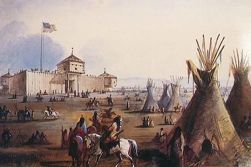
Because the area around Fort Laramie lacked forage for the Indians' horses, the treaty was negotiated and signed 30 miles downriver from the fort at the mouth of Horse Creek. Many Indians have referred to the treaty as the Horse Creek Treaty. Representatives from the Lakota, Cheyenne, Assiniboine, Gros Ventre, Mandan, Arikara, Hidatsa, Shoshone, Crow, and Arapaho took part in the treaty discussions.
The Comanche, Kiowa, and Kiowa Apache refused to send representatives to Fort Laramie because the fort was in Sioux territory. The Comanche, Kiowa, and Kiowa Apache considered the Sioux an enemy.
The United States Senate ratified the treaty, adding Article 5, to adjust compensation from fifty to ten years, if the tribes accepted the changes. Acceptance from all tribes, with the exception of the Crow, was procured. Several tribes never received the commodities promised as payments.
The Treaty Territories
The Lakota got some rather new territorial claims recognized. In 1823, a number of Lakotas had helped the United States army attack an Arikara village at Grand River (present South Dakota). The Lakotas had kept on pushing the village tribe north, so they got treaty on the former Arikara homeland along the Grand.
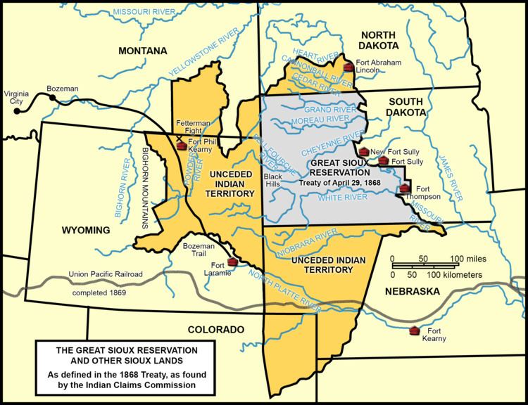
The Lakota got exclusive treaty right to the Black Hills (present South Dakota), to the consternation of the Cheyenne and the Arapahoe. "... the Sioux were given right to the Black Hills and other country that the Northern Cheyennes claimed. Their home country was the Black Hills, declared a Cheyenne historian in 1967. Arapahoe chief Black Coal complained in 1875: "I have never got anything yet for my land [the Black Hills]. It is part mine, and part the Sioux... In the first place, they came from the Missouri River and reached this place, and now they have got up this far, and they claim all this land."
The Cheyenne and Arapaho, the southernmost of the treaty tribes, held an area southward of the North Platte in common (mainly in present Wyoming and Colorado).
The Crow treaty territory (in present Montana and Wyoming) included the area westward from Powder River. Little Bighorn River ran through the center of the Crow domain.
After the Treaty
The treaty was broken almost immediately after its inception, by the Lakota and Cheyenne attacking the Crow over the next two years. In 1858 the failure of the United States to prevent the mass emigration of miners and settlers into Colorado during the Pike's Peak Gold Rush, didn't help matters any. They took over Indian lands in order to mine them, "against the protests of the Indians," and founded towns, started farms, and improved roads. Before 1861 the Cheyenne and Arapahoe "had been driven from the mountain regions down upon the waters of the Arkansas." Such emigrants competed with the tribal nations for game and water, straining limited resources and resulting in conflicts with the emigrants. The U.S. government did not enforce the treaty to keep out the emigrants. In 1864 came the Sand Creek massacre on a camp of mostly Cheyennes by Colonel John M. Chivingtons army of one hundred days volunteers. The consequence was years of war between the Cheyennes and the United States.
The situation escalated with the Grattan affair in 1854, when a detachment of U.S. soldiers attempted to enforce Act IV of the treaty regulation by lawfully entering a Sioux encampment to arrest those accused of stealing and violating the treaty, and in the process killed Chief Conquering Bear.
Despite the peace treaty of 1851, Hunkpapa Lakota chief Running Antelope killed four Arikaras in 1853.
Around the same year, a joint Cheyenne and Lakota war party found a big Crow camp in the valley of the Little Bighorn River. The Lakota One Bear killed a Crow woman taken captive by the Cheyennes.
Warriors from the other eight tribes may also have violated the treaty by intertribal fighting at that time.
Though intertribal fighting had existed before the arrival of white settlers, some of the post-treaty intertribal fighting can be attributed to mass killings of bison by white settlers and government agents. The U.S. army did not enforce treaty regulations and allowed hunters onto Native land to slaughter buffalo, providing protection and sometimes ammunition. One hundred thousand buffalo were killed each year, until they were on the verge of extinction, which threatened the tribes' subsistence. These mass killings affected all tribes thus the tribes were forced onto each other's hunting grounds, where fighting broke out.
The Lakota continued harassment of the Mandan, Hidatsa and Arikara. By summer 1862, all three tribes had been forced out of their shared treaty territory. "We, the Arikara, have been driven from our country on the other side of the Missouri River by the Sioux", stated chief White Shield in 1864. The elimination of buffalo also meant that the Yanktonai Sioux moved into Assiniboine hunting grounds in North Dakota and Montana, where the Assiniboine made peace with them.
Before long, the Crows saw their western Powder River area flooded with trespassing Lakotas in search of bison, and "... large scale battles with invading Sioux" took place near present-day city of Wyola, Montana. The outnumbered Crows were little by little displaced. "The country from the Powder River to the Yellowstone River was their country [the Crows'], until 1859, when they were driven from it by the Sioux". In 1868, after a series of battles with the United States army in the contested area, the Lakotas finally succeeded in turning a part of the Crow Indian territory of 1851 into unceded Indian territory of their own.
Later again, huge parts of the different Indian territories would in one way or another be added to the holdings of the United States. Smaller areas of the initial Indian territories became separate reservations, usually populated with Indians from the tribe, which held the treaty right in 1851.
However, the Crow territory provided in the end acreage to two different reservations. The Crow Reservation was created in the center of the original territory in 1868. The reservation of the Northern Cheyennes became a reality in 1884. It is located entirely within the boundaries of the 1851 Crow territory, after the Indians in question had "earned the right to stay in the north" after the Fort Robinson outbreak.
The Arapahoe (Northern Arapaho) settled down on the reservation of their past enemies, the Shoshone, in present Wind River Reservation in Wyoming. The Southern Cheyenne and the Arapaho live in a common reservation in present Oklahoma, also far from their 1851 treaty land.
The Assiniboine in the United States has since 1888 lived in partly Fort Peck Reservation and partly Fort Belknap Reservation, both placed north of the Missouri in present Montana. The treaty territory of the Assiniboine south of the Missouri was just a small portion of the wide range used by these northern plains Indians.