
Elevation 7,134 m (23,406 ft) Width 40 km (25 mi) N-S | Length 250 km (160 mi) E-W Age of rock Paleozoic and Mesozoic Highest point Lenin Peak Types of rock Limestone, Schist Ages of rock Paleozoic, Mesozoic | |
 | ||
State/Province Osh Province, Gorno-Badakshan Mountains Lenin Peak, Kurumdy Mountain Similar Lenin Peak, Kyzylart Pass, Fedchenko Glacier, Ismoil Somoni Peak, Taldyk Pass | ||
The Trans-Alay Range (Kyrgyz: Чоң Алай кырка тоосу, Chon Alai Krka Toosu; Russian: Заалайский хребет, Zaalaisky Khrebet; also 'Trans Alai') is the northernmost range of the Pamir Mountain System.
Contents
Geography
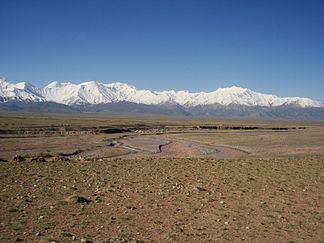
The Trans-Alay is located in the area where the Pamirs and the Tian Shan come together. This heavily glaciated range forms the border between Gorno-Badakshan province in Tajikistan and Osh Province, Kyrgyzstan, stretching eastwards until the border with China. To the north lies the Alay Valley and to the south, the Muksu River.
Peaks
The highest peak in the range is 7,134 m high Lenin Peak. The Kyzylart and Ters-Agar mountain passes geographically divide the range into three parts: the western —highest peak Sat Peak (5,900 m), the central —with some of the highest summits, including Lenin Peak, Dzerzhinsky Peak (6717 m), Oktyabrsy Peak ( 6780 m), and Marshal Zhukov Peak (6,842 m), and the eastern — highest peak Kurumdy I summit (6,614 m).