
Canton de Vielle-Aure Area 34.96 km² | Region Occitanie Time zone CET (UTC+1) Population 32 (2006) | |
 | ||
Tramezaïgues (official name) or Tramezaygues (local name) is a commune in the Hautes-Pyrénées department, in the Occitanie region of France.
Contents
Map of 65170 Trameza%C3%AFgues, France
Geography
The commune of Tramezaïgues, in the south of the Hautes-Pyrénées department, extends from the Aure Valley to the Spanish border.
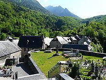
The village is located at the foot of Pic de Tramezaïgues 2,548 m (8,360 ft), and at the confluence of the Neste d'Aure and the Neste de Rioumajou. The name of Tramezaïgues is derived from the Latin description: inter ambas aquas (between two waters).
To the north of the village is the Pla d'Adet ski resort, and Aragnouet is to the west. East of the village is Loudenvielle and the Col de Val Louron-Azet. Cadeilhan-Trachère and Saint-Lary-Soulan are situated to the north-east. The Spanish border is to the south of the village.
History
The Château de Tramezaygues has been existent since the 12th century. The château was a position for monitoring the Spanish border until the French Revolution.
Sites and monuments
Demographics
In 2011, the commune had 32 inhabitants. The evolution of the number of inhabitants is known through the population censuses carried out in the town since 1793. At present, communes under 10,000 people have censuses held every five years, unlike other municipalities that have a sample survey each year.