
Existed: 1932 – present East end: Estes Park Added to NRHP November 14, 1984 Constructed 1932 East end Estes Park | NRHP Reference # 84000242 Length 77.2 km West end Grand Lake | |
 | ||
Tourist routes Trail Ridge Road/Beaver Meadow Road Similar Rocky Mountain National, Rocky Mountains, Alpine Visitor Center, Bear Lake, Longs Peak | ||
Driving trail ridge road rocky mountain national park
Trail Ridge Road is the name for a stretch of U.S. Highway 34 that traverses Rocky Mountain National Park from Estes Park, Colorado in the east to Grand Lake, Colorado in the west. The road is also known as Trail Ridge Road/Beaver Meadow National Scenic Byway,
Contents
- Driving trail ridge road rocky mountain national park
- Map of Trail Ridge Rd Colorado USA
- Trail ridge road rocky mountain national park time lapse drive
- Route description
- History
- Before the road was constructed
- References
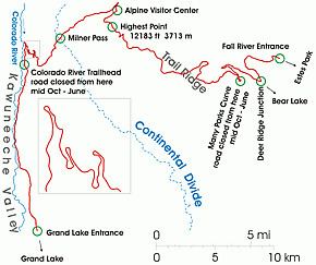
Map of Trail Ridge Rd, Colorado, USA
Trail Ridge Road is closed during the winter, and often remains closed until late spring or early summer depending on the snowpack. It requires access to Rocky Mountain National Park even for local residents.
Trail ridge road rocky mountain national park time lapse drive
Route description
From Kawuneeche Visitor Center at the park's Grand Lake Entrance, Trail Ridge Road follows the North Fork of the Colorado River north through the Kawuneeche Valley. There are several trailheads along this section of the road, notably the Colorado River Trailhead, which is the western terminus of the road segment closed during the winter.
The road crosses the Continental Divide at Milner Pass (elev. 10,758 ft or 3,279 m) and reaches a maximum elevation of 12,183 ft (3,713 m), near Fall River Pass (elev. 11,796 ft or 3,595 m). Near the highest point on the road is another pass, Iceberg Pass (elev. 11,827 ft or 3,605 m).
According to construction contracts and park maintenance files the east end of the road is located at the Fall River Entrance, however some guides state that earlier - at Deer Ridge Junction.
Trail Ridge is a high flat spur range extending east from the main range of the Rockies between Fall River in the North and the Big Thompson River in the South. The road follows Trail Ridge from the Fall River Pass near Alpine Visitor Center to the Deer Ridge Junction.
History
Fall River Road was the first road into the park's high country. It opened in 1921 and quickly proved inadequate for motor travel as a single-track road with steep grades (up to 16%), tight curves and a short annual season due to snowpack. Construction began in 1929 and was complete to Fall River Pass by July 1932, with a maximum grade of 7%. The road was complete through the Kawuneeche Valley to Grand Lake in 1938. The route followed what was known to local Arapaho Indians as the Dog Trail. Internal opposition to the construction of a road through the park's alpine tundra was overruled by National Park Service director Horace Albright, who wished to encourage park visitation. The road was designed to intrude as little as possible into the landscape, in accordance with Park Service design principles.
Hidden Valley (or Ski Estes Park) was a local ski area attraction from 1955 - 1991, off of Trail Ridge Road, now in defunct status.
Before the road was constructed
Trail Ridge had been used by Native Americans to cross the mountains between their home lands in the west and hunting areas on the east side. Arapahoe Indians called the trail located on the ridge as "taienbaa" ("Where the Children Walked") because it was so steep that children could not be carried, but had to walk. The Ute tribe crossing the mountains at Forest Canyon Pass marked their route with stone cairns. The present park Ute Trail follows partially that ancient route.
On the west side, about 1880, a wagon road was constructed along the Kawuneeche Valley from the town of Grand Lake to the mining camps of Lulu City and Gaskil. The camps were abandoned after a few years when short-lived mining boom ended and later the road was used only occasionally by hunters and tourists.