
Traversed by US 34 Elevation 3,279 m | Topo map USGS Fall River Pass | |
 | ||
Similar Rocky Mountain National, Rocky Mountains, Mount Ida, Fall River Pass, Alpine Visitor Center | ||
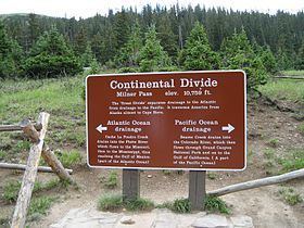
Milner Pass, elevation 10,759 ft (3,279 m) is a mountain pass in the Rocky Mountains of northern Colorado in the United States. It is located on the continental divide in the Front Range, within Rocky Mountain National Park, along the boundary between Larimer and Grand counties. The pass provides the passage over the continental divide for US 34, also known as Trail Ridge Road between Estes Park and Grand Lake. The pass is not, however, the high point on Trail Ridge Road, which crests at 12,183 ft (3,713 m) east of the pass within Rocky Mountain National Park. Along with the rest of Trail Ridge Road, the pass is generally closed in winter from the first heavy snow fall (usually October) until the opening of the road around Memorial Day. The gentle pass divides the headwaters of the Cache la Poudre River (which issues from Poudre Lake just east of the pass) and several creeks near the headwaters of the Colorado River to the west. The road near the pass provides a panoramic view of the Never Summer Mountains to the west.