
Mountain type Volcanic plug Prominence 118 m Topo map NTS 103J/04 | Elevation 125 m Age of rock 2.001327 million years | |
 | ||
Similar Haida Heritage Centre, Dixon Entrance Maritime, Delkatla Wildlife Sanctuary, Port Clements Historical, Pure Lake Provincial Park | ||
Around tow hill in masset haida gwaii british columbia canada
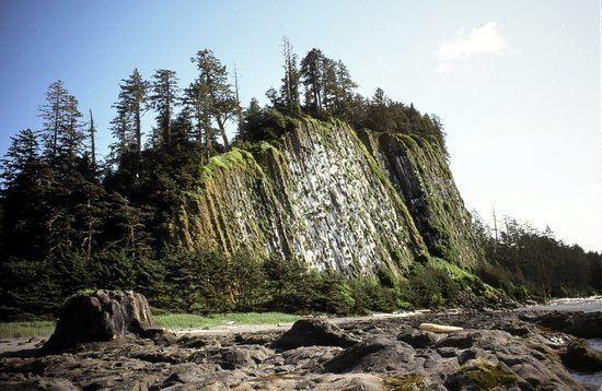
Tow Hill is a large isolated volcanic plug located 21 km (13 mi) east of Masset on the north end of the Naikoon Peninsula of northeast Graham Island in Haida Gwaii, British Columbia, Canada, east of McIntyre Bay and near the mouth of the Hiellen River, which is the site of Hiellen a now-abandoned Haida village and of the Hiellen Indian Reserve No. 2, on the site of that village. Formerly Tow Hill Provincial Park, it is now part of Naikoon Provincial Park, which covers most of the northeastern flatland of Graham Island.
Contents
- Around tow hill in masset haida gwaii british columbia canada
- Map of Tow Hill Skeena Queen Charlotte D BC Canada
- Tow hill blow hole
- References
Map of Tow Hill, Skeena-Queen Charlotte D, BC, Canada
Tow Hill is associated by the editors Canadian Mountain Encyclopedia with the Queen Charlotte Mountains which in turn form part of the Insular Mountains, but it is not physically part of the range, and is separated from mountainous parts of Graham Island by expanses of forested flatland-marsh and is properly designated as being on the Argonaut Plain, one of the lowland areas of Haida Gwaii not in the Queen Charlotte Mountains.
Tow Hill consists of faceted columnar-jointed basalt columns that solidified about two million years ago during the Pleistocene period.
"This feature is an eroded volcanic plug - the most distinctive navigational landmark on the entire North Beach. Tow is derived from a Haida word that rhymes with "cow", and means place of food. Many legends about its origin and the significance of the blowhole at the base of the hill......"