
Elevation 1,164 m | Highest point Mount Moresby | |
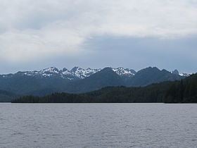 | ||
The Queen Charlotte Mountains are a mountain range comprising all mountains and small mountain ranges of Haida Gwaii (formerly the Queen Charlotte Islands), British Columbia, Canada. It is the northernmost subrange of the Insular Mountains. They are subdivided into the Queen Charlotte Ranges, which comprise a small part of southwestern Graham Island and most of Moresby Island, and the Skidegate Plateau, which runs NW-SE on central Graham Island and includes the northeastern tip of Moresby Island. To the plateau's northeast is the Queen Charlotte Lowland, which is part of the Hecate Depression and includes the Argonaut Plain.
Mount Moresby is the highest mountain associated with the Queen Charlotte Mountains, at 1,164 m (3,819 ft).
Sub-ranges
References
Queen Charlotte Mountains Wikipedia(Text) CC BY-SA