
Grid reference SO049166 1863 Station opened | Platforms in use 2 | |
 | ||
Similar Brecon Mountain Railway, Pontsticill Reservoir, Fan y Big, Talybont Reservoir, Cribyn | ||
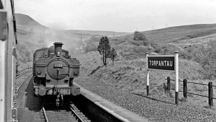
Torpantau railway station was a station in the Welsh county of Brecknockshire (now in Powys). It was served by trains on the line from Merthyr to Brecon. It was the highest station on the Brecon and Merthyr Railway.
Contents
Torpantau is a remote location, though a few passengers may have worked on the local dams, or fished there for leisure. The location was most significant in operational terms for watering engines and tying down brakes before a descent.
It is near the (now) Northern Terminus of the narrow gauge Brecon Mountain Railway.
History
Opened by the Brecon and Merthyr Tydfil Railway. In 1916 a train passed a signal at danger near the station causing a collision that killed two people. It became part of the Great Western Railway during the grouping of 1923.
Torpantau closed to passengers in December 1962 but the line was retained for freight workings to Brecon until 4 May 1964.
Torpantau Tunnel
To the north of the station lies Torpantau Tunnel, (aka Beacons Tunnel) through the Beacons pass. Torpantau Tunnel is 666 yards (609m) long, and the south-west portal, (railway mileage 14miles-2¾ chains from Brecon station), was reached after a three-mile (5 km) ascent from the Merthyr side. Exiting from the tunnel (13 miles-52¼ chains from Brecon station) to the south-east, the line descended for 6¾ miles along the side of Glyn Collwyn (now flooded to form a reservoir) and on to the former Talybont-on-Usk station and River Usk at Talybont. Thence it climbed to Pennorth and Talyllyn junction and on to Brecon.
At an elevation of 1313 ft, it was the highest standard gauge tunnel above sea level, in regular use by BR anywhere in Great Britain. Though access is discouraged, the tunnel remains accessible on foot.
The Eastern portal of the tunnel is a Grade II listed building.
The station site today
The site is a popular start point for walks in the Brecon Beacons. It lies on the National Cycle Network NCR 8 (Taff Trail).
As from December 2000, the narrow gauge Brecon Mountain Railway had extended its 2 ft-gauge line to a new terminus just-south of the historic station site and the southern entrance of Torpantau tunnel but due to motive power constraints because of the steeply graded trackbed, the extended passenger service from Dolygaer run-around loop to Torpantau terminus, a distance of 1mile-35chains, only became operational on 1 April 2014.