
 | ||
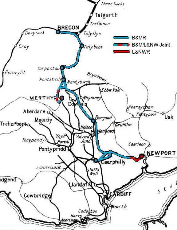
The Brecon and Merthyr Tydfil Junction Railway (B&M) was a railway in Wales running from Brecon, Brecknockshire to east of Merthyr Tydfil, Glamorgan. It was one of several railways that served the industrial areas of Glamorgan and Monmouthshire along with the Taff Vale Railway (TVR) and Great Western Railway (GWR).
Contents
- History
- Tunnels
- Later history
- Rolling stock
- Locomotive Superintendents
- The end of the Brecon and Merthyr
- Partial resurrection of the Brecon and Merthyr
- National Cycle Network
- References
The line opened in stages in the 1860s, including the Beacon Tunnel at Torpantau (Official Railway name Torpantau tunnel), 1313 feet above mean sea level, the highest railway tunnel in Britain, and a 7-mile north to south approach to the tunnel on a 1:38 2.6 % rising gradient. The line's highest point at 1314 feet, was in the railway cutting above Fochriw. Though it survived through to nationalisation in 1948, it was never profitable and consequently passenger services were withdrawn in 1962 with a complete closure to freight services to Brecon in 1964. A section of the line is now occupied by the 1 ft 11 3⁄4 in (603 mm) gauge Brecon Mountain Railway .
History
In 1836, Sir John Josiah Guest, of the Dowlais iron Works, had written of his proposal to construct a railway linking Dowlais to the valley of the River Usk, and possibly also running into Brecon. The line would have pretty nearly covered the same route as was eventually adopted by the B&M. A similar proposal suggested a line running up the Taf Fawr valley over the Brecon Beacons via Storey Arms and thence to Brecon.
The company was established by a Bill of 1859, financially supported by several prominent Brecon citizens, and the complete route from Brecon to Merthyr Tydfil was authorised the following year. The first section to open was a 6.75 miles (10.86 km) section between Brecon and Talybont-on-Usk in 1863, which reused a section of a horse-drawn tram line. The Beacons tunnel (also known as Torpantau tunnel) opened in 1868. The complicated series of amalgamations (including its originator the Hay Railway, a tram-road worked by horses opened in 1816) can best be appreciated here to explain how the B&M came about. In fact the B&M used the Hay Railway as the basis for its route between Talyllyn and Brecon. This included the tramroad tunnel (see below) at Talyllyn which required widening and deepening to allow the passage of standard gauge trains.
The system eventually came to comprise two sections of lines:
Initially, the only connection to Merthyr Tydfil was by means of a horse-drawn bus from Pant, but by 1868, a connection with Merthyr at Rhydycar Junction had been established by sharing lines with Vale of Neath, London and North Western and Taff Vale railways. This involved the building of nearly seven miles (11 km) of single line from Pontsticill to Merthyr, with an almost continuous descent of 1 in 45-50 (2.2-2 %), two complete reversals of direction and the construction of two viaducts to carry the line over the Taf Fechan at Pontsarn, and the Taf Fawr at Cefn Coed. The Pontsarn viaduct is 455 feet (139 m) long and 92 feet (28 m) height, whilst the Cefn Coed (or Pontycapel) viaduct is 770 feet (230 m) long with a height of 115 feet (35 m). North of the Pontsarn viaduct, a connection was made with the LNWR's Merthyr Extension line at Morlais Tunnel Junction from where the latter's double track entered the 1034 yard Morlais tunnel and beyond routed along the double line to Dowlais High Street and thence to Tredegar, Brynmawr and Abergavenny. The sections Merthyr to Pontsticill and Bargoed through to Brecon were laid as single lines with passing loops and usually locomotive watering facilities at principal stations. For those single lines, tokens were issued to drivers from signal boxes at such locations and being essential for safe working over single lines.
The section to the north of Pant was primarily a passenger service, serving isolated farms and villages. South of Pant, it was mainly a mineral line and carried coal from the mines down to the Newport Docks.
Tunnels
To develop routes into and through the South Wales landscape, it was forced to construct two tunnels:
Its west portal is now recorded as being blocked by landfill but its east portal is bricked up and an inspection door access is provided from the west end of a now private landscaped garden occupying the former platform area.
Later history
The line was used in World War I by intensive coal trains, dubbed 'Jellicoe Specials', from the South Wales Coalfield travelling north towards Scapa Flow via the Mid-Wales Railway for use by warships of the Royal Navy.
Prior to the two sections of line being linked, the train services had been somewhat unpunctual, with unconnected timetables, and the company acquired the unenviable reputation of operating "slow trains". They became the butt of music-hall jokes.
By 1958, the line was running three services each way on weekdays, increasing to four on Saturdays, taking around 2½ hours to run from Brecon to Newport. The service had run at a substantial loss for most of its lifetime, and was an obvious candidate for closure. Passenger services were closed from Pontsticill Junction to Merthyr Tydfil in November 1961, with the remainder of services stopping at the end of the 1962. The line was closed completely after the withdrawal of goods services in 1964.
Rolling stock
Locomotive Superintendents
The end of the Brecon and Merthyr
The line was amalgamated with the Great Western Railway following the Grouping. The ex-B&M system survived nationalisation into British Railways, but most were eventually closed during the 1960s, with all passenger services ending in December 1962. By 1980 only one short section of 10.5 miles (16.9 km) survived, serving coal traffic to Bedwas Navigation Colliery. With the demise of the coal industry in Britain the section between Bedwas and Machen was closed in 1985. The section between Machen and Bassaleg Junction (with the GWR Ebbw Valley line) remains to serve Hanson's limestone quarry.
Partial resurrection of the Brecon and Merthyr
Towards the end of the 1970s, a private company, the Brecon Mountain Railway, began to build a narrow-gauge steam-hauled tourist line on the existing 5.5-mile (8.9 km) trackbed from Pant through Pontsticill to Dol-y-gaer. The initial section of 1.75 miles (2.82 km) from Pant to Pontsticill first opened in June 1980.
After more than 30 years of hard work and extra-funding, Passenger services finally extended to Torpantau in April 2014. Thus-bringing the BMR to a total of approximately 5 miles in length.
Only one B&MR coach has survived into the present day; coach No.111 stands in a private residence. Only one goods wagon is known to still exist today; privately owned No.197 is currently at the Severn Valley Railway.
No locomotives are known to be preserved to the present day.
National Cycle Network
Some sections of the route have become part of the National Cycle Network. These routes are NCN 4 (Celtic Trail) between Machen and Trethomas, NCN 469 between Bargoed and Fochriw and NCN 8 (Taff Trail) between Torpantau and Talybont Reservoir. The section between Bedwas and Maesycwmmer is being considered to become part of NCN 468.