
Chapman code BRE HQ Brecon Designer Stephen W. Williams | Origin Brycheiniog Date dissolved 1974 | |
 | ||
Government Brecknockshire County Council (1889-1974) | ||
Brecknockshire meaning
Brecknockshire (Welsh: Sir Frycheiniog), also known as the County of Brecknock, Breconshire, or the County of Brecon is one of thirteen historic counties of Wales, and a former administrative county, and one of three counties that make up modern day Powys.
Contents
- Brecknockshire meaning
- Granite worktops brecknockshire
- Geography
- History
- Creation of county
- Governance
- Coat of arms
- Legacy
- Places of interest
- References
Granite worktops brecknockshire
Geography
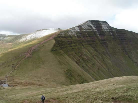
Brecknockshire is bounded to the north by Radnorshire, to the east by Herefordshire and Monmouthshire, to the south by Monmouthshire and Glamorgan, and to the west by Carmarthenshire and Cardiganshire. The county is predominantly rural and mountainous. The Black Mountains occupy the southeast of the area, the Brecon Beacons the central region, Fforest Fawr the southwest and Mynydd Epynt the north. The highest point is Pen y Fan, 2907 ft (886 m). The River Wye traces nearly the whole of the northern boundary, and the Usk flows in an easterly direction through the central valley. The main towns are Brecon, Builth Wells, Crickhowell, Hay-on-Wye, Llanwrtyd Wells, Talgarth and Ystradgynlais the largest town, at the edge of the South Wales valleys.
History
For the Kingdom of Brycheiniog, see Brycheiniog.Creation of county
The Laws in Wales Act 1535 created the County of Brecknock by combining a number of "lordships, towns, parishes, commotes and cantreds" in the "Country or Dominion of Wales. The areas combined were: "Brekenoke" (Brecknock), "Crekehowell" (Crickhowell) "Tretowre", "Penkelly", "Englisshe Talgarth", "Welsshe Talgarth", "Dynas", "The Haye" (Hay-on-Wye), "Glynebogh", "Broynlles" (Bronllys), "Cantercely" (Cantref Selyf), "Llando Blaynllynby", "Estrodewe", "Buelthe" (Builth), and "Llangors". The town of Brecknock or Brecon was declared the county town.
The county was divided into six hundreds: Builth, Crickhowell, Devynnock, Merthyr, Penkelly, and Talgarth. Brecknock was the only borough in the county. Other market towns were Builth, Crickhowell and Hay-on-Wye. Under the terms of the 1535 legislation one member of parliament was returned for the borough and one for the county.
Governance
Under the Local Government Act 1888, an elected county council was formed and the area of the county was adjusted, with a number of industrialised areas in the south of the county (Beaufort, Dukestown, Llechryd and Rassau) being transferred to Monmouthshire. The county council was based at the Shire Hall in Brecon.
Under the Public Health Act 1848 and the Local Government Act 1858 a number of towns were created Local Board Districts or Local Government Districts respectively, with local boards to govern their areas. In 1875 these, along with the Borough of Brecknock, became urban sanitary districts. At the same time the remainder of the county was divided into rural sanitary districts, some of which crossed county boundaries. The Local Government Act 1894 redesignated these as urban and rural districts. Two civil parishes were administered by rural district councils in neighbouring counties until 1934.
Coat of arms
On establishment in 1889 the Brecknockshire County Council adopted the attributed arms of Brychan, fifth century founder of Brycheiniog. The shield was quartered. In the first and fourth quarters were the purported arms of Brychan's father Anlach: sable a fess cotised or between two swords in pale argent hilted gold, the upper sword point-upwards, the lower point-downwards. In the second and third quarters were arms representing Brychan's mother, Marchell: or, three reremice (bats) 2 and 1 azure. The motto Undeb Hedd Llywddiant or "Unity, Peace, Prosperity" was used with the arms. The supposed fifth century arms were invented in the Middle Ages, heraldry having not developed until several centuries later. The county council did not obtain an official grant of armorial bearings, although the unofficial arms subsequently became the basis for those granted to the successor Brecknock Borough Council.
Legacy
The administrative county of Brecknock was abolished in 1974 by the Local Government Act 1972. The bulk of its area passed to the new county of Powys, where it became the Borough of Brecknock, one of three districts of the new county. At the same time the parishes of Penderyn and Vaynor went instead to the Cynon Valley and Merthyr Tydfil districts in Mid Glamorgan, whilst the urban district of Brynmawr and the parish of Llanelly from Crickhowell Rural District became part of Blaenau Gwent.
In 1996 a further reorganisation of local government took place in Wales, and Powys became a unitary authority. A "Brecknockshire" area was formed under a decentralisation scheme, and a "shire committee" consisting of councillors elected for electoral divisions within the former Borough of Brecknock exercises functions delegated by Powys County Council. According to the 2001 census the area covered by the shire committee had a population of 42,075.