
Construction started 1966 Opened 18 December 1997 | Width 22.9 metres (75 ft) Total length 14,000 m | |
 | ||
Bridge type Girder bridge, Box girder bridge, Orthotropic deck Similar Tokyo Bay, Bōsō Peninsula, Yokohama Bay Bridge, Rainbow Bridge, Country Farm Tokyo Ge | ||
The Tokyo Bay Aqua-Line (東京湾アクアライン, Tōkyō-wan Akua-rain), also known as the Trans-Tokyo Bay Highway, is a bridge–tunnel combination across Tokyo Bay in Japan. It connects the city of Kawasaki in Kanagawa Prefecture with the city of Kisarazu in Chiba Prefecture, and forms part of National Route 409. With an overall length of 14 km, it includes a 4.4 km bridge and 9.6 km tunnel underneath the bay—the fourth-longest underwater tunnel in the world.
Contents
Map of Tokyo Bay Aqua-Line, Japan
Overview
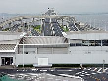
At the bridge–tunnel crossover point, there is an artificial island called Umihotaru (海ほたる, Umi-hotaru, literally meaning "sea firefly") with a rest area consisting of restaurants, shops and amusement facilities. Air is supplied to the tunnel by a distinctive tower in the middle of the tunnel, called the Kaze no Tō (風の塔, "the tower of wind"), which uses the bay's almost-constant winds as a power source.
The road opened on December 18, 1997 after 23 years of planning and 9 years of construction at a cost of 1.44 trillion yen (11.2 billion USD at the time of opening).
The Tokyo Bay Aqua-Line reduced the drive between Chiba and Kanagawa, two important industrial regions, from 90 to 15 minutes, and also contributed to cutting the travel time to the sea leisure area in the southern part of the Bōsō Peninsula from Tokyo and Kanagawa. Before the tunnel opened, one had to drive around about 100 km along the shores of Tokyo Bay and pass through downtown Tokyo.
One goal expressed during the planning of the Aqua-Line was to reduce the traffic through downtown Tokyo, but as the highway toll is quite high, the reduction in Tokyo traffic has not been as great as expected.
Many highway bus services now use the Tokyo Bay Aqua-Line, including lines from Tokyo Station, Yokohama Station and Haneda Airport to Kisarazu, Kimitsu, Kamogawa, Katsuura and Tateyama.
Tolls
The cash toll for a single trip on the Aqua-Line is ¥3000 for ordinary-size cars (¥2400 for kei cars); however, using the ETC (electronic toll collection) system, the fare is ¥2320 (¥1860 for kei cars). The ETC toll is reduced to ¥1000 on Saturdays, Sundays and Holidays. In general, tolls for usage of the Aqua-Line in either direction are collected at the mainline toll plaza on the Kisarazu end.