
Population 47,358 (Feb 2016) | Region Kantō Phone number 0470-22-3111 | |
 | ||
Weather 8°C, Wind N at 32 km/h, 73% Humidity Points of interest Awa Shrine, Aloha Garden Tateyama, Nago‑dera, Tateyama Castle, Okinoshima Park | ||
Tateyama (館山市, Tateyama-shi) is a city located in southern Chiba Prefecture, Japan. As of February, the city had an estimated population of 47,358 and a population density of 430 persons per km². The total area was 110.15 square kilometres (42.53 sq mi).
Contents
- Map of Tateyama Chiba Prefecture Japan
- Geography
- Neighboring municipalities
- Climate
- History
- Economy
- Education
- Railway
- Highway
- Airport
- Sister city relations
- Local attractions
- Notable people
- In popular culture
- References
Map of Tateyama, Chiba Prefecture, Japan
Geography
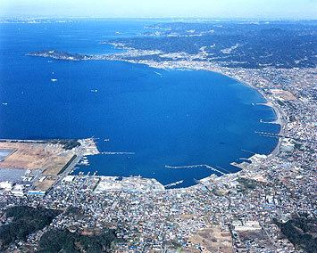
Tateyama is located at the far southern tip of the Bōsō Peninsula, facing the Pacific Ocean to the east and south, and the entrance to Tokyo Bay on the west.
Neighboring municipalities
Chiba Prefecture
Climate
Tateyama has a humid subtropical climate (Köppen climate classification Cfa) with very warm summers and cool winters. Precipitation is significant throughout the year, but is somewhat lower in winter.
History
The area of present-day Tateyama was part of ancient Awa Province, dominated by the Satomi clan during the Sengoku period, who ruled from Tateyama Castle. After the Edo period, most of the territory was part of the feudal domain of Tateyama Domain (館山藩, Tateyama-han). After the start of the Meiji period, Tateyama Town (in Awa District), Chiba Prefecture was proclaimed on April 1, 1889. It annexed neighboring Toyosu Village on April 1, 1914, and merged with Hōjō Town to form Tateyamahōjō Town on April 18, 1933.
The city of Tateyama was proclaimed on November 3, 1939, with the merger of Tateyamahōjō with Nago and Funagata towns. The city was a base for the Imperial Japanese Navy Air Service until the end of World War II. Tateyama expanded on May 3, 1954 by annexing six surrounding villages.
Economy
The economy of Tateyama is based on commercial fishing, horticulture and summer tourism. The population of Tateyama surges during much of the summer. Tateyama is a popular destination for vacationing in the summer due to its proximity to Tokyo and its reputation as a "beach" or "surf town". There are numerous resort and holiday hotels dotting the coastline. Every August, tens of thousands of people gather on Hōjō Beach for the annual fireworks display.
Education
Tateyama has 10 elementary schools, four middle schools and three high schools. The city also has four special education schools.
Railway
Highway
Airport
Sister city relations
Local attractions
Notable people
In popular culture
The popular television drama Beach Boys, which originally aired on Japanese television in the summer of 1997, although with a plot set in the Shōnan region, was filmed largely in Tateyama.