
Opening date 1974 Height 215 m (705 ft) Opened 1974 Construction began 1960 | Impounds Naryn River Length 292.5 m (960 ft) Surface area 284.3 km² Impound Naryn River | |
 | ||
Similar Kurpsai Dam, Nurek Dam, Laxiwa Dam, Schardara‑Talsperre, Song Kol Lake | ||
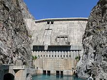
Toktogul Dam is a hydroelectric and irrigation dam on the Naryn River in the Jalal-Abad Province of Kyrgyzstan. It is concrete gravity dam with height of 215 metres (705 ft) and length of 292.5 metres (960 ft). It is a part of the Naryn-Syr Darya cascade. It is named after Toktogul Satilganov.
Contents
Map of Toktogul Dam, Kyrgyzstan
The Toktogul Hydroelectric Station has installed capacity of 1,200 MW, which makes it the largest power plant in the country. It has four turbines with capacity of 300 MW each.
Toktogul Reservoir (Kyrgyz: Токтогул суу сактагычы, IPA: [toqtoʁul suː sɑqtɑʁɯtʃɯ]; Russian: Токтогульское водохранилище) is the largest of the reservoirs on the path of the Naryn River, a northern tributary of the Syr Darya. The reservoir has total capacity of 19.5 cubic kilometres (15,800,000 acre·ft), of which 14 cubic kilometres (11,000,000 acre·ft) is active capacity. Its length is 65 kilometres (40 mi) and its surface area is 284.3 square kilometres (109.8 sq mi). The maximal depth of the reservoir is 120 metres (390 ft).
The city of Kara-Köl, south of the reservoir (downstream from its dam) housed the dam construction workers, and currently is home to the hydro power plant staff. The city of Toktogul is located north of the reservoir.
Environmental and Social Impact
The reservoir was created in 1976 after construction works on the dam were completed and the Kementub Valley was flooded. The reservoir flooded more than 26 thousand hectares of land, of which 21.2 thousand hectares of agricultural land, 26 communities including large settlement Toktogul were displaced and the main road through the region was re-routed. Archaeologists excavated barrows dating back as far as the 8th century AD before the sites were lost.
2009 crisis
Toktogul Reservoir reached a critical state with regard to water level within the dam in 2009. A cold dry winter, combined with sales to foreign countries as well as increased domestic demand have left the reservoir at a fraction of its capacity. Electrical rationing is currently being employed throughout the entire country with outages lasting up to 11 hours every day.