
Postcode(s) 4580 Population 1,994 (2011 census) | Tin Can Bay Inskip Postal code 4580 Local time Saturday 11:15 PM | |
 | ||
Location 218 km (135 mi) from Brisbane72 km (45 mi) from Maryborough, Queensland52 km (32 mi) from Gympie Weather 23°C, Wind S at 18 km/h, 72% Humidity | ||
Tin Can Bay is a town and locality in the Wide Bay–Burnett region in Queensland, Australia. The locality is split between the Fraser Coast Region (the northern part of the locality) and the Gympie Region (southern part of the locality), but the town itself is within Gympie Region.
Contents
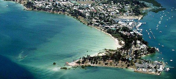
Map of Tin Can Bay QLD 4580, Australia
Geography
Tin Can Bay is 218 kilometres (135 mi) north of the state capital, Brisbane.
The locality of Tin Can Bay is bounded on the east by the Great Sandy Strait, a pristine waterway protected by World Heritage listed Fraser Island. The area is a Ramsar Convention Wetland of International Importance and an Important Bird Area of Australia.
The town is located on a peninsula between Snapper Creek and the Great Sandy Strait.
Tin Can Bay is the nearest town to the Australian Army's Wide Bay Training Area.
History
The town was originally called Wallu, but was changed to Tin Can Bay in 1937. The origins of "Tin Can" are uncertain, but is believed to be derived from an indigenous name, possibly ''tinchin'' meaning ''mangrove'' in the Yugarabul dialect of the Yuggera language, or '''tinken''' meaning '''vine with large ribbed leaves''' from Doombarah Clan, Dulinbara dialect, Kabi language, or '''Tuncanbar''', thought to refer to the dugongs that frequent the inlet. European settlement began in the 1870s as the point where logs would be floated to the timber mills at Maryborough. Tin Can Bay later became, and still remains, an important fishing port, with a focus on prawns as well as recreational fishing.
Wallu State School opened on 1 February 1934 and was renamed Tin Can Bay State School in 1937.
Tin Can Bay was formerly in the Shire of Cooloola until its amalgamation in 2008 into the Gympie Region.
At the 2006 census, Tin Can Bay had a population of 1,994.
Visitor attractions
The seaside town is a popular holiday destination. Recreational facilities include hotels, holiday units and caravan parks, with houseboats and yachts for hire and a marina. Active sports facilities include an 18-hole golf course, two bowls clubs, tennis courts and an outdoor swimming pool. The Tin Can Bay Country Club serves residents and visitors in the Tin Can Bay, Cooloola Cove and Rainbow Beach areas.
An important tourist feature is the regular arrival of wild Australian humpback dolphins which usually appear early mornings next to the Norman Point boat ramp. These dolphins can be hand fed under close supervision. Bird watching is another popular activity as Tin Can Bay is home to a wide variety of birds.
Each September the town hosts the Tin Can Bay Seafood Festival, a day of family fun, with entertainment, novelty competitions such as mullet throwing and prawn eating, helicopter joy flights over the bay, seafood and market stalls. Other events throughout the year include the Bay to Bay Yacht Race, Dragonboat Regatta, Cooloola Coast Flower Show and the Foreshore Family Carnival from Boxing Day to New Year's Eve.
Amentities
There is an excellent public boat ramp into Snapper Creek with boat-washing facilities and ample trailer parking.
A vehicular ferry operates at nearby Inskip Point providing access to Fraser Island.