
Population 0 (2011 census) Cooloola Pacific Ocean | Postcode(s) 4580 Postal code 4580 | |
 | ||
Location 57 km (35 mi) ENE of Gympie224 km (139 mi) N of Brisbane | ||
Cooloola is a locality in the Gympie Region, Queensland, Australia. Cooloola recorded no people in the 2011 census.
Contents
Map of Cooloola QLD 4580, Australia
Geography
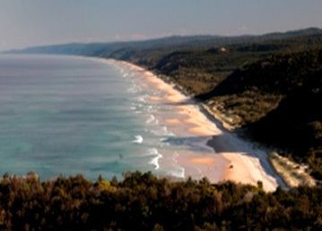
Cooloola is a coastal locality, being bounded by the Pacific Ocean to the east including the major headland, Double Island Point. From Double Island Point, Rainbow Beach extends to the west and then to the north, while Teewah Beach stretches for many kilometres to the south. Off the coast of Double Island Point is Wolf Rock which is Queensland's most important habitat area for the critically endangered grey nurse shark. It is a mating area and a high number of females and pregnant females have been seen there.
The locality's north-west boundary is Tin Can Inlet off Tin Can Bay. The locality is entirely within the Great Sandy National Park and is undeveloped apart from some basic bushwalking and camping infrastructure.
Heritage listings
Cooloola has a number of heritage-listed sites, including:
Attractions
The Cooloola Great Walk is a 5-day walking track through Cooloola through to Rainbow Beach (to the north) and Noosa North Shore to the south.