
Elevation 1,951.5 ft (594.8 m) Topo map USGS Timms Hill | Prominence 425 ft (130 m) Easiest route Hiking | |
 | ||
Similar Mount Arvon, Charles Mound, Eagle Mountain, Campbell Hill, Jerimoth Hill | ||
Timms Hill is the highest natural point in the U.S. state of Wisconsin. Located in north-central Wisconsin in Timms Hill County Park in the Town of Hill in Price County, Timms Hill has an elevation of 1,951.5 ft (595 m). It is less than 1 mile (1.6 km) south of Highway 86, about midway between Ogema and Spirit and about 23 miles (37 km) west of Tomahawk.
Map of Timms Hill, Hill, WI 54459, USA
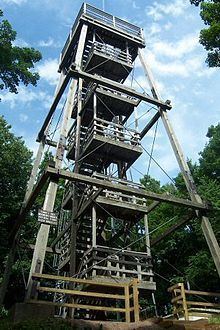
A public lookout tower on top offers outstanding views of the surrounding area. Visible to the southeast is Rib Mountain (elev. 1,924 ft, 586 m), 44 miles away by line of sight.
The ten-mile Timms Hill Trail connects to the Ice Age Trail, a National Scenic Trail stretching 1,200 miles (1,900 km) across glacial terrain in Wisconsin.
References
Timms Hill Wikipedia(Text) CC BY-SA