Puneet Varma (Editor)

Timeline of the 2011 Pacific hurricane season

Updated on
Edit
Like
Comment
Share on FacebookTweet on TwitterShare on LinkedInShare on Reddit
Timeline of the 2011 Pacific hurricane season

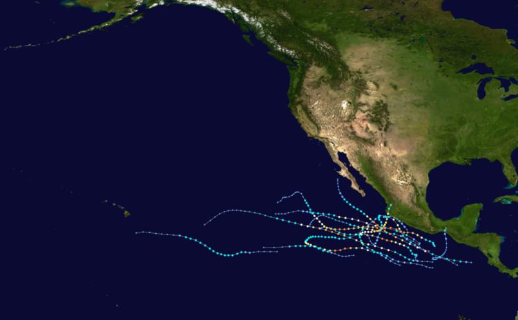
The 2011 Pacific hurricane season officially started on May 15, 2011 in the eastern Pacific, designated as the area east of 140°W, and on June 1, 2011 in the central Pacific, which is between the International Date Line and 140°W, and lasted until November 30, 2011. These dates typically limit the period of each year when most tropical cyclones form in the eastern Pacific basin. This timeline documents all the storm formations, strengthening, weakening, landfalls, extratropical transitions, as well as dissipation.

Contents

The first storm of the season, Hurricane Adrian formed off the southwest coast of Mexico. Thirteen tropical cyclones developed during the season. Most of these attained tropical storm status, and seven attained hurricane status. However this streak ended when Tropical Storm Fernanda formed and dissipated, never having reached hurricane strength.

May

  • No tropical cyclones formed during the month of May.
  • May 15
  • 0700 UTC (12 a.m. PDT) – The 2011 East Pacific hurricane season officially begins.
  • June

    June 1

  • The 2011 Central Pacific hurricane season officially begins.
  • June 7

  • 12:00 UTC (5:00 a.m. PDT) – Tropical Depression One-E develops from an area of low pressure about 370 mi (595 km) south of Acapulco, Mexico.
  • June 8

  • 00:00 UTC (5:00 p.m. PDT, June 7) – Tropical Depression One-E strengthens into Tropical Storm Adrian roughly 345 mi (555 km) south of Acapulco, Mexico.
  • June 9

  • 00:00 UTC (5:00 p.m. PDT, June 8) –Tropical Storm Adrian strengthens into a Category 1 hurricane approximately 270 mi (435 km) south-southwest of Acapulco, Mexico.
  • 12:00 UTC (5:00 a.m. PDT) – Hurricane Adrian strengthens into a Category 2 hurricane about 310 mi (500 km) southwest of Acapulco, Mexico.
  • 18:00 UTC (11:00 a.m. PDT) – Hurricane Adrian strengthens into a Category 3 hurricane roughly 350 mi (565 km) southwest of Acapulco, Mexico.
  • June 10

  • 00:00 UTC (5:00 p.m. PDT, June 9) – Hurricane Adrian strengthens into a Category 4 hurricane approximately 320 mi (515 km) south of Manzanillo, Mexico.
  • 06:00 UTC (11:00 p.m. PDT, June 9) – Hurricane Adrian attains its peak intensity with maximum sustained winds of 140 mph (225 km/h) and a minimum barometric pressure of 944 mbar (hPa; 27.88 inHg) about 315 mi (505 km) south-southwest of Manzanillo, Mexico.
  • 18:00 UTC (11:00 a.m. PDT) – Hurricane Adrian weakens to a Category 3 hurricane roughly 355 mi (570 km) southwest of Manzanillo, Mexico.
  • June 11

  • 06:00 UTC (11:00 p.m. PDT June 10) – Hurricane Adrian rapidly weakens to a Category 1 hurricane approximately 455 mi (730 km) southwest of Manzanillo, Mexico.
  • 18:00 UTC (11:00 a.m. PDT) – Hurricane Adrian rapidly weakens to a tropical storm about 585 mi (940 km) southwest of Manzanillo, Mexico.
  • June 12

  • 12:00 UTC (5:00 a.m. PDT) – Tropical Storm Adrian degenerates into trough of low pressure while located roughly 570 mi (915 km) southwest of Cabo San Lucas, Mexico.
  • June 19

  • 06:00 UTC (11:00 p.m. PDT, June 18) – Tropical Depression Two-E develops from an area of low pressure approximately 260 mi (420 km) south-southeast of Acapulco, Mexico.
  • 18:00 UTC (11:00 a.m. PDT) – Tropical Depression Two-E strengthens into Tropical Storm Beatriz about 195 mi (315 km) south-southwest of Acapulco, Mexico.
  • June 20

  • 18:00 UTC (11:00 a.m. PDT) - Tropical Storm Beatriz strengthens into a Category 1 hurricane roughly 205 mi (330 km) south-southeast of Manzanillo, Mexico.
  • June 21

  • 06:00 UTC (11:00 p.m. PDT, June 20) – Hurricane Beatriz attains its peak intensity with maximum sustained winds of 90 mph (150 km/h) and a minimum pressure of 977 mbar (hPa; 28.85 inHg) approximately 40 mi (65 km) south-southeast of Manzanillo, Mexico.
  • 12:00 UTC (5:00 a.m. PDT) – Hurricane Beatriz weakens to a tropical storm about 45 mi (75 km) west of Manzanillo, Mexico.
  • June 22

  • 00:00 UTC (5:00 p.m. PDT, June 21) – Tropical Storm Beatriz weakens to a tropical depression roughly 105 mi (165 km) west of Manzanillo, Mexico.
  • 06:00 UTC (11:00 p.m. PDT, June 21) - Tropical Depression Beatriz dissipates approximately 85 mi (140 km) west of Manzanillo, Mexico.
  • July

    July 7
  • 1500 UTC (8 a.m. PDT) – Tropical Depression Three-E forms south of Mexico.
  • July 8
  • 0300 UTC (8 p.m. PDT July 7) – Tropical Depression Three-E strengthens to Tropical Storm Calvin.
  • 2100 UTC (2 p.m. PDT) – Tropical Storm Calvin strengthens to a Category 1 hurricane.
  • July 9
  • 1500 UTC (8 a.m. PDT) – Hurricane Calvin weakens to a tropical storm.
  • July 10
  • 0300 UTC (8 p.m. PDT July 9) – Tropical Storm Calvin degenerates into a remnant low.
  • July 17
  • 1500 UTC (8 a.m. PDT) – Tropical Depression Four-E forms 265 miles (425 km) south-southwest of San Salvador.
  • 1800 UTC (11 a.m. PDT) - Tropical Depression Four-E strengthens to Tropical Storm Dora.
  • July 20
  • 0300 UTC (8 p.m. PDT July 19) - Tropical Storm Dora strengthens to a Category 1 hurricane.
  • 1800 UTC (11 a.m. PDT) - Hurricane Dora strengthens to a Category 2 hurricane.
  • 2100 UTC (2 p.m. PDT) - Hurricane Dora strengthens into a Category 3 hurricane.
  • July 21
  • 0000 UTC (5 p.m. PDT July 20) - Hurricane Dora strengthens to a Category 4 hurricane.
  • July 22
  • 0300 UTC (8 p.m. PDT July 21) - Hurricane Dora weakens into a Category 3 hurricane.
  • 0900 UTC (2 a.m. PDT) - Hurricane Dora weakens into a Category 2 hurricane.
  • 1200 UTC (5 a.m. PDT) - Hurricane Dora weakens into a Category 1 hurricane.
  • July 23
  • 0000 UTC (5 p.m. PDT July 22) - Hurricane Dora weakens into a Tropical Storm.
  • July 24
  • 2100 UTC (2 p.m. PDT July 24) - Tropical Storm Dora degenerates into a remnant low.
  • July 31
  • 0600 UTC (11 p.m. PDT July 30) – An area of disturbed weather 435 mi (700 km) south of Acapulco is upgraded to Tropical Depression Five-E.
  • 1200 UTC (5 a.m. PDT) – Tropical Depression Five-E strengthens to Tropical Storm Eugene.
  • August

    August 1
  • 1800 UTC (11 a.m. PDT) – Tropical Storm Eugene strengthens to a Category 1 hurricane.
  • August 2
  • 1800 UTC (11 a.m. PDT) – Hurricane Eugene intensifies to a Category 2 hurricane.
  • August 3
  • 0600 UTC (11 p.m. PDT August 2) – Hurricane Eugene intensifies to a Category 3 major hurricane while located approximately 575 mi (925 km) south-southwest of the southern tip of the Baja California peninsula.
  • 1800 UTC (11 a.m. PDT) – Hurricane Eugene rapidly intensifies to a Category 4 hurricane.
  • 2100 UTC (2 p.m. PDT) – Hurricane Eugene attains its peak intensity with a barometric pressure of 942 mbar (hPa; 27.82 inHg) and winds of 140 mph (220 km/h).
  • August 4
  • 0600 UTC (11 p.m. PDT August 3) – Hurricane Eugene rapidly weakens to a Category 3 hurricane.
  • 1800 UTC (11 a.m. PDT) – Hurricane Eugene rapidly weakens to a Category 2 hurricane.
  • August 5
  • 0000 UTC (5 p.m. PDT August 4) – Hurricane Eugene rapidly weakens further to a Category 1 hurricane.
  • 1200 UTC (11 a.m. PDT) – Hurricane Eugene is downgraded to a tropical storm.
  • August 6
  • 1200 UTC (11 a.m. PDT) – Tropical Storm Eugene degenerates into a post-tropical remnant low pressure area roughly 1,130 mi (1,820 km) west of the southern tip of the Baja California peninsula.
  • August 15
  • 2100 UTC (2 p.m PDT) - Tropical Depression Six-E formed about 1,630 mi (2,620 km) east-southeast of Ka Lae, Hawaii.
  • August 16
  • 1500 UTC (8 a.m. PDT) - Tropical Depression Six-E strengthens into Tropical Storm Fernanda.
  • 2100 UTC (2 p.m. PDT) - Tropical Depression Seven-E formed 215 mi (346 km) south of Acapulco, Mexico.
  • August 17
  • 0900 UTC (2 a.m. PDT) - Tropical Depression Seven-E strengthens into Tropical Storm Greg.
  • August 18
  • 0300 UTC (8 p.m. PDT) - Tropical Storm Greg strengthens into a Category 1 hurricane.
  • August 19
  • 1500 UTC (8 a.m. PDT) - Hurricane Greg weakens into a tropical storm.
  • 2100 UTC (11 a.m. HST) - Tropical Storm Fernanda weakens to a tropical depression.
  • August 20
  • 0300 UTC (5 p.m. HST August 19) - Tropical Depression Fernanda degenerates to a post-tropical cyclone.
  • August 21
  • 0300 UTC (8 p.m. PDT August 20) - Tropical Storm Greg weakens to a tropical depression.
  • 1500 UTC (8 a.m. PDT) - Tropical Depression Greg degenerates into a remnant low.
  • August 31
  • 1800 UTC (11 a.m. PDT) - Tropical Depression Eight forms 45 miles (72 km) west-northwest of Lázaro Cárdenas, Mexico.
  • September

    September 1
  • 0900 UTC (8 p.m. PDT August 31) - Tropical Depression Eight-E dissipates.
  • September 21
  • 0600 UTC (11 p.m. PDT September 20) - Tropical Depression Nine-E forms about 170 miles south-southeast of Puerto Escondido, Mexico.
  • 1200 UTC (5 a.m. PDT)- Tropical Depression Nine-E strengthens to Tropical Storm Hilary.
  • September 22
  • 1200 UTC (5 a.m. PDT) - Tropical Storm Hilary strengthens into a Category 1 hurricane.
  • 1800 UTC (11 a.m. PDT) - Hurricane Hilary strengthens into a Category 2 hurricane.
  • 0000 UTC (5 p.m. PDT) - Hurricane Hilary strengthens into a Category 3 hurricane.
  • September 23
  • 0600 UTC (11 p.m. PDT September 22) Hurricane Hilary strengthens into a Category 4 hurricane.
  • 1800 UTC (11 a.m. PDT) - Hurricane Hilary attains peak intensity with winds of 145 mph.
  • September 25
  • 0600 UTC (11 p.m. PDT September 24) - Hurricane Hilary weakens into a Category 3 hurricane.
  • September 26
  • 1800 UTC (11 a.m. PDT) - Hurricane Hilary restrengthens into a Category 4 hurricane.
  • September 27
  • 0600 UTC (11 p.m. PDT September 26) - Hurricane Hilary weakens into a Category 3 hurricane.
  • 1800 UTC (11 a.m. PDT) - Hurricane Hilary weakens into a Category 2 hurricane.
  • September 28
  • 0600 UTC (11 p.m. PDT September 27) - Hurricane Hilary weakens into a Category 1 hurricane.
  • September 29
  • 0600 UTC (11 p.m. PDT September 28) - Hurricane Hilary weakens into a tropical storm.
  • September 30
  • 0600 UTC (11 p.m. PDT September 29) - Tropical Storm Hilary weakens into a tropical depression.
  • 1200 UTC (5 a.m. PDT) - Tropical Depression Hilary dissipates into a remnant low.
  • October

    October 6
  • 0300 UTC (8 p.m. PDT October 5) - Tropical Depression Ten-E forms about 625 miles (1005 km) south of Manzanillo, Mexico.
  • 0600 UTC (11 p.m. PDT October 5) - Tropical Depression Eleven-E forms about 885 miles (1425 km) south-southwest of the southern tip of Baja California.
  • 1200 UTC (5 a.m. PDT) - Tropical Depression Eleven-E strengthens into Tropical Storm Irwin.
  • 2100 UTC (2 p.m. PDT) - Tropical Depression Ten-E strengthens into Tropical Storm Jova.
  • October 7
  • 0600 UTC (11 p.m. PDT October 6) - Tropical Storm Irwin strengthens into a Category 1 hurricane.
  • 1800 UTC (11 a.m. PDT) - Hurricane Irwin strengthens into a Category 2 hurricane.
  • October 8
  • 1800 UTC (11 a.m. PDT) - Hurricane Irwin weakens into a tropical storm.
  • 2100 UTC (2 p.m. PDT) - Tropical Storm Jova strengthens into a Category 1 hurricane.
  • October 10
  • 0300 UTC (8 p.m. PDT October 9) - Hurricane Jova strengthens into a Category 2 hurricane.
  • 0900 UTC (2 a.m. PDT) - Hurricane Jova strengthens into a Category 3 major hurricane.
  • October 12
  • 0700 UTC (12 a.m. PDT) - Hurricane Jova makes landfall in Jalisco, Mexico.
  • 0900 UTC (2 a.m. PDT) - Tropical Depression Twelve-E forms just south of the Gulf of Tehuantepec.
  • October 13
  • 0000 UTC (5 p.m. PDT October 12) - Tropical Storm Irwin weakens into a tropical depression.
  • 0300 UTC (8 p.m. PDT October 12) - Tropical Depression Jova degenerates into a remnant low.
  • 0300 UTC (8 p.m. PDT October 12) - Tropical Depression Twelve-E degenerates into a remnant low.
  • 1800 UTC (11 a.m. PDT) - Tropical Depression Irwin restrengthens into a tropical storm.
  • October 15
  • 1800 UTC (11 a.m. PDT) - Tropical Storm Irwin weakens into a tropical depression.
  • October 16
  • 1800 UTC (11 a.m. PDT) - Tropical Depression Irwin degenerates into a remnant low.
  • November

    November 18
  • 2100 UTC (1 p.m. PST) - Tropical Depression Thirteen-E forms about 480 miles (775 km) south of Acapulco, Mexico.
  • November 20
  • 2100 UTC (1 p.m. PST) - Tropical Depression Thirteen-E strengthens into Tropical Storm Kenneth.
  • November 21
  • 1500 UTC (7 a.m. PST) - Tropical Storm Kenneth strengthens into a Category 1 hurricane.
  • November 22
  • 0300 UTC (7 p.m. PST November 21) - Hurricane Kenneth strengthens into a Category 2 hurricane.
  • 0900 UTC (1 a.m. PST) - Hurricane Kenneth strengthens into a Category 3 hurricane.
  • 1500 UTC (7 a.m. PST) - Hurricane Kenneth strengthens into a Category 4 hurricane, becoming the strongest eastern Pacific hurricane in November on record.
  • November 23
  • 0900 UTC (1 a.m. PST) - Hurricane Kenneth weakens into a Category 2 hurricane.
  • 1500 UTC (7 a.m. PST) - Hurricane Kenneth weakens into a Category 1 hurricane.
  • 2100 UTC (1 p.m. PST) - Hurricane Kenneth weakens into a tropical storm.
  • November 25
  • 0900 UTC (1 a.m. PST) - Tropical Storm Kenneth weakens into a tropical depression.
  • 1500 UTC (7 a.m. PST) - Tropical Depression Kenneth becomes post-tropical 1250 miles (2010 km) west-southwest of the southern tip of Baja California.
  • November 30
  • The 2011 Pacific hurricane season officially ends.
  • References

    Timeline of the 2011 Pacific hurricane season Wikipedia