
Formed September 21, 2011 Fatalities None | Dissipated October 3, 2011 Damage Minimal Highest winds 233 km/h | |
 | ||
Lowest pressure 942 mbar (hPa); 27.82 inHg Date 21 September 2011 – 30 September 2011 Affected areas Southwestern Mexico, Mexico Similar Hurricane Dora, Hurricane Adrian, Hurricane Kenneth, Hurricane Beatriz, Hurricane Jova | ||
Hurricane Hilary was a powerful tropical cyclone that developed during the 2011 Pacific hurricane season. The fourth Category 4 and major hurricane, seventh hurricane, and eighth tropical storm of the season, Hilary developed from an area of low pressure off the Pacific coast of Central America in mid-September. Organizing quickly, the system became a tropical depression on September 21, after gaining enough organization to be declared as such. While moving towards the west-northwest, the depression continued to gather strength, and was subsequently upgraded to a tropical storm just several hours later. On September 21, Hilary was declared as a Category 1 hurricane, while located close to the Mexican coastline, where the storm brought heavy rainfall and flooding. Undergoing rapid intensification, Hilary strengthened into a Category 4 hurricane on September 22, recognized with a distinct eye feature. Beginning to enter cooler Ocean temperatures, Hilary began to weaken by September 25, but briefly restrengthened into a Category 4 the following day. Atmospheric conditions became increasingly unfavorable late on September 26, and the system began to weaken. During the afternoon hours of September 30, Hilary became a remnant low, while located several hundred miles away from any landmasses.
Contents
Meteorological history
On September 7, a tropical wave moved off the coast of Africa. During the nighttime hours of September 18, an area of showers and thunderstorms associated with a broad area of low pressure was observed a couple of hundred miles south-southeast of the Gulf of Tehuantepec as it moved westward. The following day, the area of disturbed weather began to become better organized, and the National Hurricane Center (NHC) upgraded its chances of tropical cyclone development to the "Medium" category. Moving towards the west-northwest, the area of disturbed weather was upgraded into a tropical depression during the morning hours of September 21, after radar data showed that the low pressure area had gained enough structure to be declared as such. Due to a favorable upper regime characterized by low wind shear and a moist environment, the National Hurricane Center predicted intensification into a hurricane within two days. Later on September 21, despite the fact that rainbands on the western semicircle of the depression became less defined, the depression acquired gale-force winds, and was subsequently upgraded into a tropical storm, earning the name Hilary. That afternoon, the Government of Mexico issued a tropical storm watch for parts of the Mexican coastline, indicating that rainfall totals of 3–5 inches, with isolated 10 inch amounts, were possible.
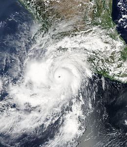
On September 22, while quickly strengthening, Hilary was upgraded to a Category 1 hurricane on the Saffir-Simpson hurricane scale. It was noted by the National Hurricane Center that strengthening into a major hurricane, defined by a hurricane with winds that exceed 111 miles per hour (179 km/h), was likely over the coming days. Just several hours later, Hilary was recorded as a rapidly strengthening Category 2 hurricane located in close proximity of the Mexican coastline. At 00:00 UTC September 23, Hilary was upgraded into a major hurricane, the fourth of the season. Continuing to rapidly strengthen, Hilary became a Category 4 hurricane just a few hours later after becoming a Category 3, and reached a peak intensity of 145 mph (235 km/h) at 0600 UTC September 23 (11 p.m. AST September 22). However, the storm began to enter an area of higher wind shear and cooler ocean temperatures on September 24, and Hilary began to weaken. The hurricane weakened back down to a Category 3 hurricane early on September 25, but was later upgraded briefly to a Category 4 again the following afternoon.
Several hours later, the storm was once again downgraded into a Category 3 hurricane, and during the afternoon hours of September 27, Hilary was further downgraded into a Category 2 hurricane. Early the following morning, Hilary weakened into a Category 1 hurricane, and weakened into a tropical storm on September 28. Losing a lot of its convection on September 30, the National Hurricane Center noted that Hilary had weakened into a tropical depression. Several hours later, after sustaining no deep convection atop its centre, Hilary was declared a remnant low, located several hundred miles away from any landmasses. Over the next 3 days Hilary's remnant low subsequently moved towards the southwest, before dissipating after 1200 UTC on October 3, about 1,050 mi (1,690 km) to the west of the southern tip of Baja California.
Preparations and impact
The NHC noted the possibility of up to 10 in (250 mm) of rain in the high-terrain of Guerrero and Oaxaca, and large swells were expected to impact coastal areas. Tropical cyclone watches and warnings were therefore issued for portions of the Pacific coast of Mexico. A red emergency alert was additionally in place for the region; officials urged residents to be prepared to evacuate, and tourists were advised to stay indoors. Due to rough surf, small craft advisories were put in effect, and swimmers were advised to take extreme caution. The port of Acapulco was closed for small vessels, and a moderate to high alert for strong winds and rain was noted.
The storm's outer bands produced torrential rains over Chiapas and Tabasco, with 24-hour accumulations of up to 8.58 in (218 mm) in Tabasco. Also in the state, four rivers overflowed their banks; one river received 51 in (1,300 mm) of excess water in a single day. Low-lying areas, such as grasslands and pastures, experienced major flooding, prompting farmers to evacuate their livestock. In Villahermosa, the downpours resulted in the collapse of water drains, flooding many streets and stranding cars. Across Guerrero, three people were initially reported missing, but all three were later found. Twenty-thousand residents were advised to evacuated due to rising floodwaters. Offshore Colima, large waves of 9 ft (2.7 m) to 15 ft (4.6 m) high were recorded.